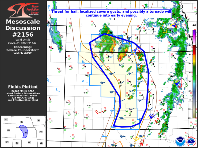
   Mesoscale Discussion 2156
   NWS Storm Prediction Center Norman OK
   0535 PM CDT Mon Oct 21 2024

   Areas affected...Parts of southwest/south-central NE into
   west-central KS

   Concerning...Severe Thunderstorm Watch 692...

   Valid 212235Z - 220000Z

   The severe weather threat for Severe Thunderstorm Watch 692
   continues.

   SUMMARY...A threat for hail, localized severe gusts, and possibly a
   tornado will continue into early evening.

   DISCUSSION...Strong storms have developed from
   southwest/south-central NE into north-central KS, immediately to the
   east/northeast of a compact mid/upper-level cyclone. A narrow zone
   of modest instability (MLCAPE of 500-1000 J/kg) remains in place
   along/east of a dryline, with sufficient deep-layer shear for storm
   organization. Cool temperatures aloft will continue to support a
   threat of sporadic hail with any marginal supercell structures,
   along with potential for isolated strong to severe gusts. A tornado
   also cannot be ruled out, both with any persistent supercells within
   the narrow warm sector, and also in closer proximity to a weak
   surface low from northwest KS into southwest NE, where there is some
   overlap between ambient surface vorticity and steeper low-level
   lapse rates/buoyancy.

   Farther south into south-central KS, deep convection has struggled
   to mature thus far. However, cumulus has increased over the last
   hour, and a narrow zone of near 60 F dewpoints is supporting locally
   greater buoyancy (with MLCAPE approaching 1000 J/kg). A supercell or
   two could evolve within this region into early evening, with some
   threat for hail, localized severe gusts, and a tornado.

   Farther east, elevated convection continues to develop near the
   eastern edge of WW 692. Continued moistening above the surface will
   maintain MUCAPE around 1000 J/kg, and an isolated hail threat could
   eventually spread east of WW 692 with time, though it remains
   uncertain if any watch expansion to the east will be needed in the
   short term.

   ..Dean/Guyer.. 10/21/2024

   ...Please see www.spc.noaa.gov for graphic product...

   ATTN...WFO...TOP...ICT...GID...LBF...DDC...GLD...

   LAT...LON   40730009 40589942 40399862 40029808 39209786 37819801
               37249834 37109876 37099921 37139960 37869929 38279932
               39049996 39810067 40360084 40730009
|


 @NWSSPC