|
| Mesoscale Discussion 2155 |
|
< Previous MD Next MD >
|
|
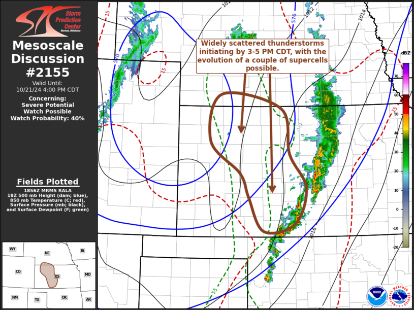
   Mesoscale Discussion 2155
   NWS Storm Prediction Center Norman OK
   0159 PM CDT Mon Oct 21 2024

   Areas affected...parts of western into central Kansas and adjacent
   southern Nebraska

   Concerning...Severe potential...Watch possible

   Valid 211859Z - 212100Z

   Probability of Watch Issuance...40 percent

   SUMMARY...Widely scattered strong to severe thunderstorm development
   appears increasingly possible by 3-5 PM CDT.  The stronger storms
   will probably pose the risk for severe hail, but a brief tornado or
   two may also be possible.  It is not certain this will require a
   severe weather watch, but trends are being monitored for this
   possibility.

   DISCUSSION...The southwestern flank of relatively cool
   boundary-layer air stabilized by convective precipitation is
   gradually eroding, roughly from the McCook and Hill City vicinities
   south-southeastward toward Medicine Lodge.  Along and to the
   immediate west, a narrow corridor of modest boundary-layer moisture
   (characterized by mid/upper 50s F surface dew points) is being
   maintained long enough to contribute to CAPE on the order of 500 to
   1000 J/kg, as the leading edge of the compact mid-level cold core
   continues to shift across/east of the central high plains.

   Attempts at deepening convective development are ongoing within this
   corridor of destabilization, most notably to the west-southwest and
   southwest of Hill City.  It appears the corridor of stronger
   destabilization will continue to develop slowly northeastward and
   eastward through the remainder of the afternoon.  As this occurs, it
   probably will become increasingly supportive of thunderstorm
   initiation through the 20-22Z time frame.  In the presence of
   favorable low-level and deep-layer shear, beneath 40 kt southerly
   850 mb flow veering to 50-60 kt southwesterly at 500 mb, the
   environment appears conducive to the development of a couple of
   supercells.  Large hail appears the primary potential severe hazard,
   but low-level hodographs might be conducive to a brief tornado or
   two.

   ..Kerr/Guyer.. 10/21/2024

   ...Please see www.spc.noaa.gov for graphic product...

   ATTN...WFO...ICT...GID...DDC...GLD...

   LAT...LON   40270079 39959901 38909877 38119830 37299863 37139954
               37909997 38460022 39200110 40270079
|
|
Top/All Mesoscale Discussions/Forecast Products/Home
|
|


 @NWSSPC