|
| Mesoscale Discussion 2154 |
|
< Previous MD Next MD >
|
|
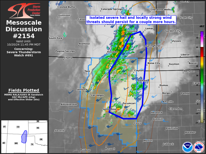
   Mesoscale Discussion 2154
   NWS Storm Prediction Center Norman OK
   1117 PM CDT Sun Oct 20 2024

   Areas affected...the southern High Plains

   Concerning...Severe Thunderstorm Watch 691...

   Valid 210417Z - 210545Z

   The severe weather threat for Severe Thunderstorm Watch 691
   continues.

   SUMMARY...Potential for isolated severe hail from quarters to golf
   balls, and locally strong gusts of 45-60 mph should persist for
   another couple hours, before likely weakening overnight. Additional
   watch issuance is unlikely.

   DISCUSSION...Discrete cells have largely remain separated in two
   distinct convective swaths; one east of the Sangre de Cristo
   Mountains across the Raton Mesa, and separately near the I-40
   corridor in eastern NM. These areas are gradually converging and
   this process should accelerate over the next couple hours. A couple
   persistent supercells have spread slowly northeast in both regimes
   from far southeast CO to east-central NM. The FDX VWP data appears
   to be sampling the previously advertised increasing weakness in the
   hodograph from 1-3 km AGL. In conjunction with gradual nocturnal
   cooling within a moist low-level air mass, supercell structures
   should diminish, as well as become increasingly elevated in time
   overnight. 00Z HREF members along with the NSSL-MPAS are rather
   consistent in supporting a decreasing severe threat after 06Z.

   ..Grams.. 10/21/2024

   ...Please see www.spc.noaa.gov for graphic product...

   ATTN...WFO...LUB...AMA...PUB...ABQ...

   LAT...LON   37330367 37900332 38030285 37700259 37170254 36110268
               35170277 34630305 34640366 34880432 35520422 36200434
               36460434 37330367
|
|
Top/All Mesoscale Discussions/Forecast Products/Home
|
|


 @NWSSPC