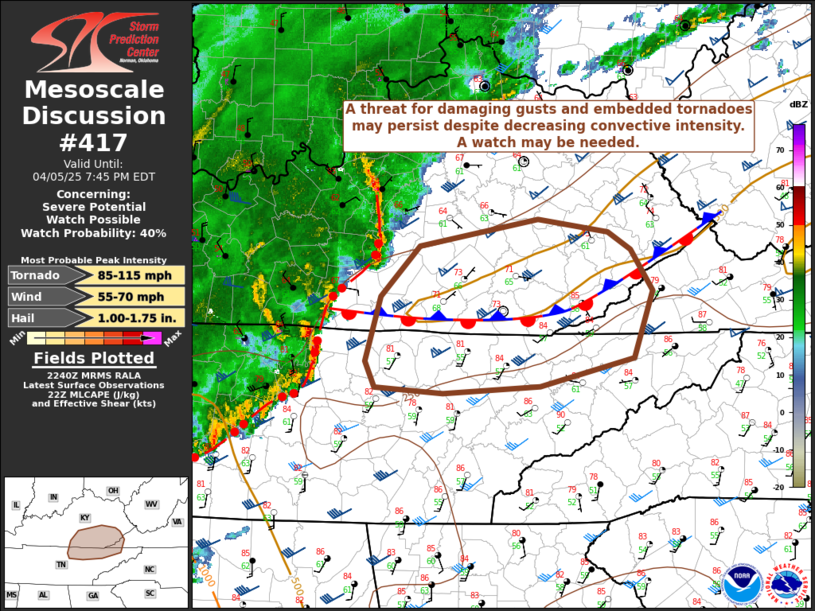
   Mesoscale Discussion 0417
   NWS Storm Prediction Center Norman OK
   0542 PM CDT Sat Apr 05 2025

   Areas affected...parts of eastern Kentucky...eastern Tennessee...and
   far western Virginia

   Concerning...Severe potential...Watch possible

   Valid 052242Z - 052345Z

   Probability of Watch Issuance...40 percent

   SUMMARY...Convective intensity is expected to decrease with time
   across portions of eastern Tennessee, eastern Kentucky, and far
   western Virginia, however a threat for damaging gusts and embedded
   tornadoes may persist. A watch may be needed.

   DISCUSSION...Storms are currently ongoing across middle Tennessee
   and central Kentucky including a bowing segment impacting the
   Nashville metro area with a few tornadoes and a 58-kt gust at BNA.
   Ahead of these storms a strong low-level jet continues, which
   maintains a threat for damaging winds in the near term. This
   low-level jet also provides low-level shear (40-50 kts 0-1 km shear)
   to maintain a threat for tornadoes both in this bowing segment and
   in any other discrete storms.

   An ACARS profile from 2046 UTC from BNA shows modest low-level
   buoyancy to support these threats, as well, however it also shows
   warm temperatures aloft, with 700-500 mb lapse rates near 6 C/km.
   These warm temperatures aloft combined with a decrease in surface
   moisture with eastward extent may limit the eastward extent of the
   threat for damaging gusts and tornadoes. Due to the decrease in
   buoyancy with time, expect convective intensity to trend downward
   over the next couple hours. Despite this, a watch may be needed to
   cover the wind and embedded tornado threat, and convective trends
   will be monitored.

   ..Supinie/Hart.. 04/05/2025

   ...Please see www.spc.noaa.gov for graphic product...

   ATTN...WFO...MRX...JKL...LMK...OHX...

   LAT...LON   36958261 36398281 36158381 36098482 36148555 36368564
               36908548 37348508 37568383 37458308 37308284 36958261

   MOST PROBABLE PEAK TORNADO INTENSITY...85-115 MPH
   MOST PROBABLE PEAK WIND GUST...55-70 MPH
   MOST PROBABLE PEAK HAIL SIZE...1.00-1.75 IN
|


 @NWSSPC