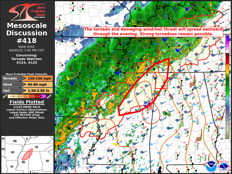
   Mesoscale Discussion 0418
   NWS Storm Prediction Center Norman OK
   0618 PM CDT Sat Apr 05 2025

   Areas affected...Northern MS...northwest AL...southwest TN

   Concerning...Tornado Watch 124...125...

   Valid 052318Z - 060045Z

   The severe weather threat for Tornado Watch 124, 125 continues.

   SUMMARY...The threat for tornadoes, damaging wind, and isolated hail
   will spread eastward through the evening.

   DISCUSSION...A small storm cluster with embedded supercells has
   evolved across north-central MS this evening, with another cluster
   noted into southwest TN. The environment downstream of the southern
   cluster remains favorable for tornadic supercells, with strong
   buoyancy (with MLCAPE of 2000-3000+ J/kg), favorable boundary-layer
   moisture and deep-layer shear, and locally backed surface winds
   supporting 0-1 km SRH above 200 m2/s2. Despite the complex storm
   mode, the presence of embedded supercells within this environment
   will continue to support a tornado threat, including strong-tornado
   potential. One or more swaths of severe/damaging wind will also be
   possible with these clusters, along with isolated hail.

   Buoyancy is somewhat weaker into southern TN, but some threat for
   all severe hazards may accompany the northernmost cluster as it
   encounters a downstream outflow boundary.

   ..Dean.. 04/05/2025

   ...Please see www.spc.noaa.gov for graphic product...

   ATTN...WFO...OHX...BMX...HUN...MEG...JAN...

   LAT...LON   34598916 35388818 35618741 34718754 33728826 33328898
               33139002 33469007 34078963 34598916

   MOST PROBABLE PEAK TORNADO INTENSITY...120-150 MPH
   MOST PROBABLE PEAK WIND GUST...65-80 MPH
   MOST PROBABLE PEAK HAIL SIZE...1.50-2.50 IN
|


 @NWSSPC