|
| Mesoscale Discussion 416 |
|
< Previous MD Next MD >
|
|
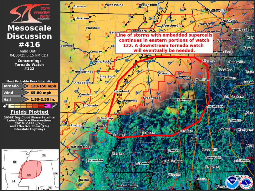
   Mesoscale Discussion 0416
   NWS Storm Prediction Center Norman OK
   0314 PM CDT Sat Apr 05 2025

   Areas affected...far northeast Louisiana...northern Mississippi and
   northwest Alabama.

   Concerning...Tornado Watch 122...

   Valid 052014Z - 052215Z

   The severe weather threat for Tornado Watch 122 continues.

   SUMMARY...A line of storms with embedded supercells continues across
   eastern portions of watch 122. A downstream tornado watch will
   eventually be needed across northeast Louisiana, northern/central
   Mississippi and northwest Alabama.

   DISCUSSION...A line of storms with embedded supercells is slowly
   drifting east near the Arkansas/Mississippi border. SPC mesoanalysis
   shows 2500 J/kg MLCAPE ahead of this activity with 50 to 60 knots of
   effective shear. This will support a continued threat for supercells
   capable of all severe weather hazards. The JAN VWP currently shows a
   relatively straight low-level hodograph where deeper mixing has
   occurred. However, winds have remained more backed across northern
   Mississippi where some sheltering from upper-level clouds has
   occurred. Expect low-level shear to strengthen later this evening as
   the low-level jet intensifies closer to 00Z. This cluster of
   supercells across southeast Arkansas may eventually congeal into
   another bowing segment across northern Mississippi with an increased
   severe wind threat this afternoon.

   In addition, scattered showers have developed across central
   Mississippi within the unstable, uncapped airmass. Most of the
   activity has not had any lightning, indicating it is relatively
   shallow within the deep moist layer shown by the 12Z JAN RAOB.
   Recently some lightning has been observed with the deeper storms
   across eastern Mississippi. It is still unclear whether this
   activity will congeal into one more more supercells this
   afternoon/evening. If a mature supercell can develop, the
   environment would support all severe weather hazards including the
   potential for a strong tornado.

   A tornado watch will eventually be needed for this region by late
   this afternoon to early evening for the storms moving out of
   northern Louisiana and eastern Arkansas. However, if the storms
   across central/eastern Mississippi continue to deepen/mature, a
   tornado watch may be needed sooner.

   ..Bentley/Guyer.. 04/05/2025

   ...Please see www.spc.noaa.gov for graphic product...

   ATTN...WFO...BMX...HUN...MEG...JAN...LZK...

   LAT...LON   32989155 34179118 34829040 35038964 34988798 34688746
               33498739 32758785 32288895 32288989 32209110 32399163
               32989155

   MOST PROBABLE PEAK TORNADO INTENSITY...120-150 MPH
   MOST PROBABLE PEAK WIND GUST...65-80 MPH
   MOST PROBABLE PEAK HAIL SIZE...1.50-2.50 IN
|
|
Top/All Mesoscale Discussions/Forecast Products/Home
|
|


 @NWSSPC