|
| Mesoscale Discussion 415 |
|
< Previous MD Next MD >
|
|
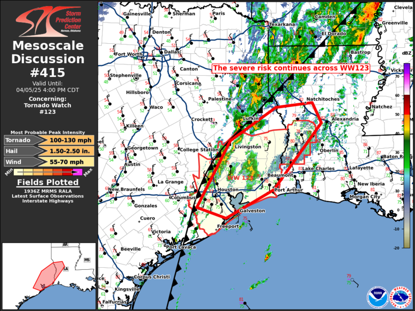
   Mesoscale Discussion 0415
   NWS Storm Prediction Center Norman OK
   0237 PM CDT Sat Apr 05 2025

   Areas affected...parts of southeast Texas into Louisiana

   Concerning...Tornado Watch 123...

   Valid 051937Z - 052100Z

   The severe weather threat for Tornado Watch 123 continues.

   SUMMARY...Damaging winds, a few tornadoes and hail remain possible
   across WW123.

   DISCUSSION...As of 1935 UTC, scattered thunderstorms have initiated
   and are maturing along a line roughly from HOU to SHV. While storms
   have been slow to organize, recent CAPPI and Echo tops show
   increasing core heights with time. Mid-level rotation has also
   increased, signaling further intensification is likely over the
   coming hours. The environment ahead of these cells is very moist and
   strongly unstable with low 70s F dewpoints contributing to upwards
   of 2500 J/kg of MLCAPE. Effective shear of 45-50 kt from the 18z LCH
   sounding will continue to support supercells as flow aloft
   strengthens through the afternoon.

   Radar and HRRR trends suggest storms will continue to gradually
   intensify this afternoon with an associated severe risk. Some
   consolidation into a linear cluster also appears likely as the cold
   front/composite outflow boundary to the west has begun to increase
   in forward speed. The strong mid-level shear will still favor
   semi-discrete embedded elements with a risk for all hazards.
   Additionally, weak convection along a pre-frontal confluence axis
   may eventually support an isolated storm ahead of the cluster. Given
   the broadly favorable environment and the gradual increase in
   intensity, the severe risk continues across much of WW123.

   ..Lyons.. 04/05/2025

   ...Please see www.spc.noaa.gov for graphic product...

   ATTN...WFO...LCH...SHV...HGX...

   LAT...LON   29449585 30919502 31659385 31759290 31309267 29839391
               29219511 29449585

   MOST PROBABLE PEAK TORNADO INTENSITY...100-130 MPH
   MOST PROBABLE PEAK WIND GUST...55-70 MPH
   MOST PROBABLE PEAK HAIL SIZE...1.50-2.50 IN
|
|
Top/All Mesoscale Discussions/Forecast Products/Home
|
|


 @NWSSPC