|
| Mesoscale Discussion 414 |
|
< Previous MD Next MD >
|
|
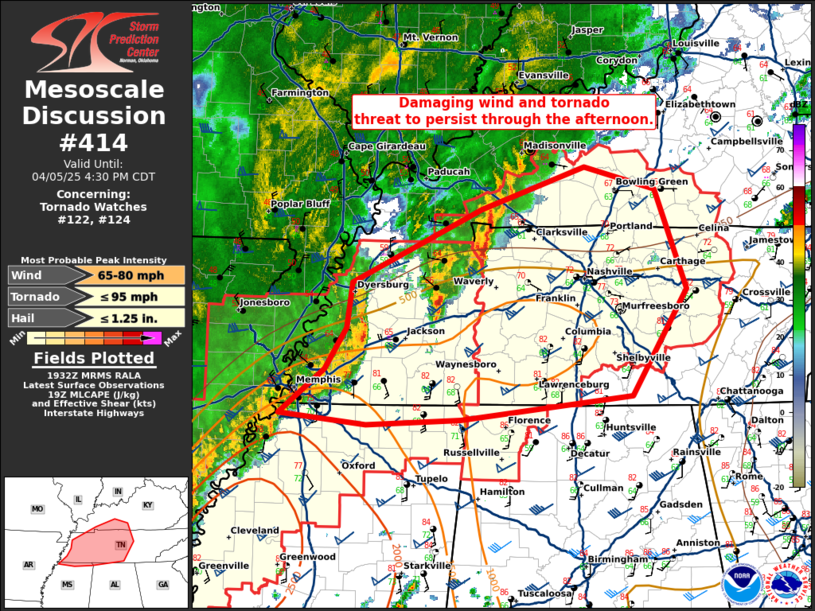
   Mesoscale Discussion 0414
   NWS Storm Prediction Center Norman OK
   0234 PM CDT Sat Apr 05 2025

   Areas affected...western Tennessee to far southern Kentucky

   Concerning...Tornado Watch 122...124...

   Valid 051934Z - 052130Z

   The severe weather threat for Tornado Watch 122, 124 continues.

   SUMMARY...A damaging wind and tornado threat is expected to persist
   through the afternoon.

   DISCUSSION...A well-developed squall line continues across western
   Tennessee. Measured wind gusts have been mostly in the 35 to 45 knot
   range recently as the apex of the bow weakened somewhat as it moved
   into an airmass featuring low 50s temperatures. The only exception
   was a measured 51 kt gust at KHKA at 1917Z on the northern end of
   the bow.  Some enhancement of this bow is possible over the next 1
   to 2 hours as it interacts with a more unstable surface airmass
   along the front across southern Tennessee with temperatures in the
   low 80s and dewpoints in the mid 60s. In addition, some enhancement
   of the low-level jet (between 1 and 2 km) has been sampled by the
   KOHX VWP. This will further support maintenance of the MCS and its
   associated wind threat, and will also aid in the low-level shear
   favorable for some embedded tornado threat. Expect the apex of this
   bow to continue to orient along the instability gradient, along and
   slightly south of I-40 between Memphis and Nashville, TN.

   ..Bentley.. 04/05/2025

   ...Please see www.spc.noaa.gov for graphic product...

   ATTN...WFO...LMK...OHX...HUN...PAH...MEG...

   LAT...LON   35328971 35708947 36128941 36798795 37188678 36988598
               36058563 35078624 34868817 34808923 34909022 35328971

   MOST PROBABLE PEAK TORNADO INTENSITY...UP TO 95 MPH
   MOST PROBABLE PEAK WIND GUST...65-80 MPH
   MOST PROBABLE PEAK HAIL SIZE...UP TO 1.25 IN
|
|
Top/All Mesoscale Discussions/Forecast Products/Home
|
|


 @NWSSPC