|
| Mesoscale Discussion 413 |
|
< Previous MD Next MD >
|
|
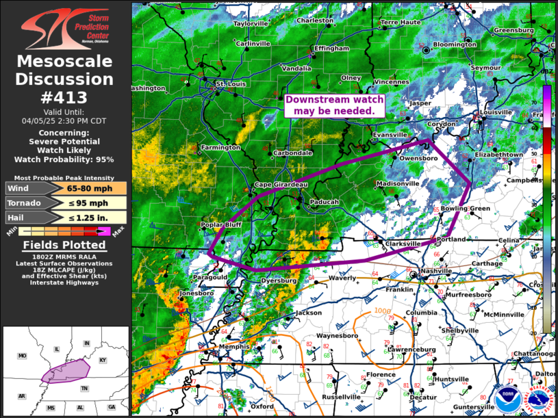
   Mesoscale Discussion 0413
   NWS Storm Prediction Center Norman OK
   0103 PM CDT Sat Apr 05 2025

   Areas affected...southeast Missouri...southern Illinois...western
   Kentucky and far northern Tennessee

   Concerning...Severe potential...Watch likely

   Valid 051803Z - 051930Z

   Probability of Watch Issuance...95 percent

   SUMMARY...A downstream watch may be needed from southeast Missouri
   across western Kentucky.

   DISCUSSION...A well-established bow has developed across northeast
   Arkansas with multiple measured wind gusts between 60 and 80 mph.
   This bow is mostly on the cool side of the surface boundary, but the
   cold air is shallow enough to support some downdrafts and continued
   severe wind gusts. While this bow likely will undergo some weakening
   as it moves into increasingly deep cold air north of the boundary,
   there is a reservoir of better instability across western Kentucky.
   This may provide enough buoyancy to support some severe wind gusts
   this afternoon. There is currently minimal surface-based instability
   forecast north of the TN/KY border (per SPC mesoanalysis) and with
   extensive cloudcover, it may be difficult for surface based
   destabilization. However, if even weak surface based instability can
   develop this far north, strong low-level shear would support a
   tornado threat.

   In addition, a band of storms has continued to strengthen across
   western Tennessee with some supercell structures apparent. These
   storms could move north of watch 122 with some severe threat this
   afternoon. A watch may be needed in the next 1 to 2 hours to cover
   the threat from the bow and this pre-squall line convection.

   ..Bentley/Guyer.. 04/05/2025

   ...Please see www.spc.noaa.gov for graphic product...

   ATTN...WFO...LMK...OHX...PAH...MEG...

   LAT...LON   36228945 36409016 36449022 36789000 37208942 37648805
               37968661 37378592 36678630 36368766 36228945

   MOST PROBABLE PEAK TORNADO INTENSITY...UP TO 95 MPH
   MOST PROBABLE PEAK WIND GUST...65-80 MPH
   MOST PROBABLE PEAK HAIL SIZE...UP TO 1.25 IN
|
|
Top/All Mesoscale Discussions/Forecast Products/Home
|
|


 @NWSSPC