|
| Mesoscale Discussion 412 |
|
< Previous MD Next MD >
|
|
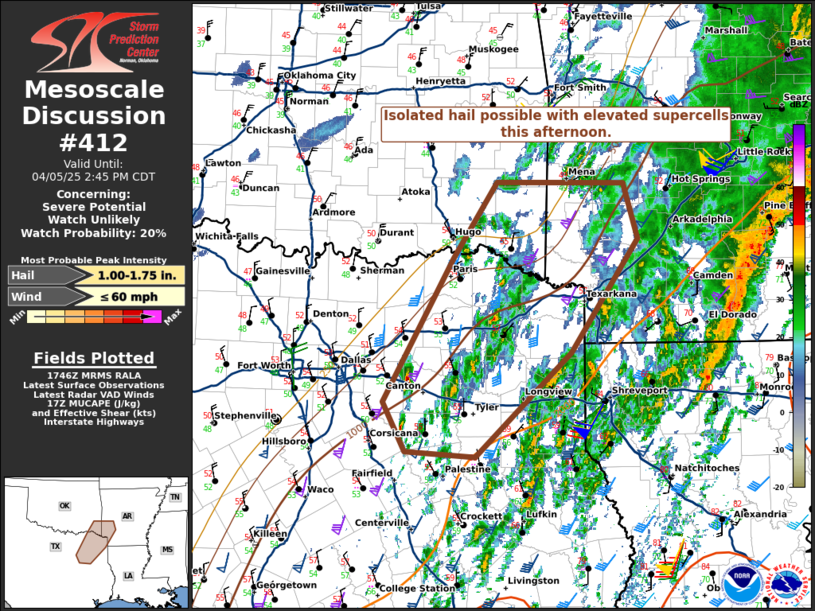
   Mesoscale Discussion 0412
   NWS Storm Prediction Center Norman OK
   1248 PM CDT Sat Apr 05 2025

   Areas affected...parts of northeast Texas...Southwest Arkansas and
   far southeast Oklahoma

   Concerning...Severe potential...Watch unlikely

   Valid 051748Z - 051945Z

   Probability of Watch Issuance...20 percent

   SUMMARY...Maturing elevated storms may pose a risk for hail through
   the afternoon hours.

   DISCUSSION...As of 1745 UTC, regional radar imagery showed
   intensifying elevated convection northwest of the well-defined
   frontal corridor across eastern TX. Recent reports of severe hail in
   Navarro County, along with increasing CAPPI/MESH cores these storms
   will likely continue to intensify. SPC mesoanalysis shows 500-1000
   J/kg of MUCAPE atop surface temperatures in the 50s and 40s F.
   Southwesterly mid-level shear of 50-60 kt is supporting of
   supercells. With most of the CAPE distributed above the freezing
   layer, severe hail with the max potential near 1.75 inches is likely
   with the deeper cores.

   HRRR guidance and radar trends suggest these storms may persist for
   several hours farther northeast into parts of OK and AR. While
   buoyancy gradually decreases, MUCAPE around 500 J/kg should remain
   sufficient for isolated hail with the deeper supercell structures.
   Given the isolated nature of the threat, a WW is not expected, but
   trends are being monitored.

   ..Lyons/Guyer.. 04/05/2025

   ...Please see www.spc.noaa.gov for graphic product...

   ATTN...WFO...LZK...SHV...TSA...FWD...

   LAT...LON   32469630 33839552 34559502 34549359 34009342 32939418
               31939527 31989605 32469630

   MOST PROBABLE PEAK WIND GUST...UP TO 60 MPH
   MOST PROBABLE PEAK HAIL SIZE...1.00-1.75 IN
|
|
Top/All Mesoscale Discussions/Forecast Products/Home
|
|


 @NWSSPC