|
| Mesoscale Discussion 410 |
|
< Previous MD Next MD >
|
|
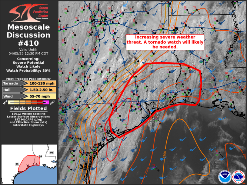
   Mesoscale Discussion 0410
   NWS Storm Prediction Center Norman OK
   1006 AM CDT Sat Apr 05 2025

   Areas affected...Southeast Texas into southwest Louisiana

   Concerning...Severe potential...Watch likely

   Valid 051506Z - 051730Z

   Probability of Watch Issuance...80 percent

   SUMMARY...The severe weather threat is increasing across southeast
   Texas this morning and will continue to increase into southwest
   Louisiana by this afternoon.

   DISCUSSION...A moist, uncapped airmass is in place across east Texas
   and Louisiana ahead of a strong frontal boundary. Extensive
   stratocumulus is in place this morning south of the front, but it is
   expected to thin through the morning with strong surface heating and
   destabilization expected by mid-day. As this occurs, more robust
   convective development is expected along the front in east Texas.
   Strong deep-layer shear and this strong instability should support
   the potential for supercells with a threat for all severe hazards
   including strong tornadoes. Despite the uncapped warm-sector, expect
   open warm sector storm development to be minimal given the warm
   800-650mb temperatures sampled by the SHV and LCH 12Z RAOBs with
   primary storm development along and near the front where forcing is
   maximized. Deep layer flow parallel to this front may result in a
   messy storm mode, but the environment should support embedded
   supercells capable of large hail, severe wind gusts, and tornadoes
   (some which could be strong).

   ..Bentley/Guyer.. 04/05/2025

   ...Please see www.spc.noaa.gov for graphic product...

   ATTN...WFO...LCH...SHV...HGX...CRP...

   LAT...LON   30729564 31209503 31249439 31209341 30919270 30459265
               29829277 29649292 29679322 29709350 29659383 29429460
               29109499 28879527 28439616 28669648 29129660 29599637
               30309595 30729564

   MOST PROBABLE PEAK TORNADO INTENSITY...100-130 MPH
   MOST PROBABLE PEAK WIND GUST...55-70 MPH
   MOST PROBABLE PEAK HAIL SIZE...1.50-2.50 IN
|
|
Top/All Mesoscale Discussions/Forecast Products/Home
|
|


 @NWSSPC