|
| Mesoscale Discussion 409 |
|
< Previous MD Next MD >
|

|
   Mesoscale Discussion 0409
   NWS Storm Prediction Center Norman OK
   0931 AM CDT Sat Apr 05 2025

   Areas affected...far northeast Texas and northern Louisiana across
   southern and central Arkansas and into far western Tennessee and
   northwest Mississippi

   Concerning...Severe potential...Watch likely

   Valid 051431Z - 051630Z

   Probability of Watch Issuance...80 percent

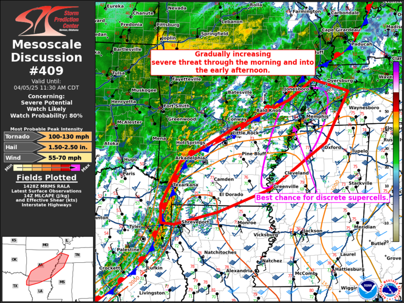
   SUMMARY...A severe threat will gradually increase through the
   morning and into the early afternoon from the ArkLaTex to the
   Mid-Mississippi Valley with the potential for large hail, severe
   wind gusts, and tornadoes (some which may be strong).

   DISCUSSION...A line of storms has become better defined in the last
   30 minutes across far northeast Texas into southwest Arkansas. SPC
   mesoanalysis indicates an uncapped airmass which is supported by the
   12Z SHV RAOB. However, this sounding also shows a few significant
   temperature inversions between 800 and 650mb which should limit most
   open warm sector storm development. Interpolation between this
   sounding and the 12Z LZK sounding suggest there is likely a zone
   across southern Arkansas which currently supports stronger
   convective development. In addition, visible satellite only shows
   broken cloudcover across southern Arkansas with some heating likely
   which will further destabilize the airmass and make stronger
   surface-based storms more likely. Strong effective shear (57 knots
   per SHV 12Z RAOB) will support embedded supercells capable of severe
   wind gusts and perhaps some hail. Strong low-level shear on the 12Z
   SHV RAOB (282 0-1km SRH) should maintain through the day, even if
   low-level flow veers amid greater heating/mixing. Therefore, a
   tornado threat, including the threat for strong tornadoes exists.

   A separate threat area also exists across eastern Arkansas and
   northwest Mississippi into western Tennessee where a line of storms
   has developed. These storms are not that strong and do not have a
   lot of structure at this time, but as the environment continues to
   destabilize, one or more supercells could develop from this
   activity. Similar low-level shear to areas farther west is being
   sampled by the KNQA VWP. If a mature supercell can develop in this
   environment and remain south of the baroclinic zone, it will pose a
   threat for all severe hazards including strong tornadoes.

   ..Bentley/Guyer.. 04/05/2025

   ...Please see www.spc.noaa.gov for graphic product...

   ATTN...WFO...MEG...JAN...LZK...SHV...

   LAT...LON   33019436 34109379 34989215 35669051 36168980 35848871
               34568943 33429111 32859266 32539394 32569434 33019436

   MOST PROBABLE PEAK TORNADO INTENSITY...100-130 MPH
   MOST PROBABLE PEAK WIND GUST...55-70 MPH
   MOST PROBABLE PEAK HAIL SIZE...1.50-2.50 IN
|
|
Top/All Mesoscale Discussions/Forecast Products/Home
|
|


