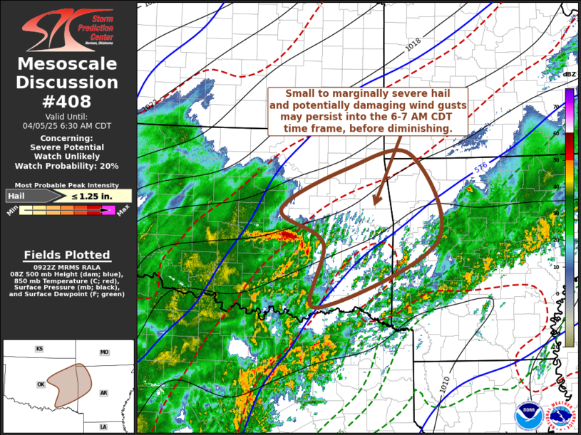
   Mesoscale Discussion 0408
   NWS Storm Prediction Center Norman OK
   0423 AM CDT Sat Apr 05 2025

   Areas affected...parts of e cntrl OK into nwrn AR and swrn MO

   Concerning...Severe potential...Watch unlikely

   Valid 050923Z - 051130Z

   Probability of Watch Issuance...20 percent

   SUMMARY...Small to marginally severe hail and potentially damaging
   surface gusts may continue at least another hour or two into the 6-7
   AM CDT time frame, before probably diminishing.

   DISCUSSION...Warmer elevated mixed-layer air, atop the potentially
   buoyant elevated moist layer, appears to responsible for suppressing
   ongoing convective development near and south of the Red River.  The
   more intense convection has remained focused in a short arcing band
   to the north, roughly within the thermal gradient around 700 mb, on
   the northern edge of the elevated mixed-layer.  This has been
   accompanied by sustained small to marginally severe hail, and it
   appears that this could persist at least another couple hours.

   Additionally, it does appear that this activity has generated an
   appreciable surface pressure perturbation, based on recent ASOS
   observations from Pauls Valley, where a 6-7 mb 2 hourly surface
   pressure fall was noted.  This has accelerated already strong
   northerly near surface wind fields, with several gusts in excess of
   severe limits being observed across south central Oklahoma during
   the past couple of hours.

   As convection fills in across eastern Oklahoma into western
   Oklahoma, in response to large-scale ascent, it remains unclear how
   much longer this will continue, but it is possible that it could
   persist into the 11-12Z time frame.

   ..Kerr/Mosier.. 04/05/2025

   ...Please see www.spc.noaa.gov for graphic product...

   ATTN...WFO...LZK...SGF...SHV...TSA...OUN...

   LAT...LON   35629677 36339537 36569405 35059351 33949603 35059589
               35629677

   MOST PROBABLE PEAK HAIL SIZE...UP TO 1.25 IN
|


 @NWSSPC