|
| Mesoscale Discussion 407 |
|
< Previous MD Next MD >
|
|
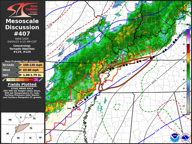
   Mesoscale Discussion 0407
   NWS Storm Prediction Center Norman OK
   0211 AM CDT Sat Apr 05 2025

   Areas affected...northeast AR...wrn TN...adjacent swrn KY

   Concerning...Tornado Watch 119...120...

   Valid 050711Z - 050915Z

   The severe weather threat for Tornado Watch 119, 120 continues.

   SUMMARY...Risk for additional tornadoes and locally damaging wind
   gusts may persist into the 4-5 AM CDT time frame.  A new WW may be
   issued or Tornado Watch 119 locally extended.

   DISCUSSION...A developing mesoscale convective vortex is now near
   the Jonesboro AR vicinity and migrating northeastward around 40 kt,
   with a narrow vigorous line of convection arcing southward toward
   the Greater Memphis area.  To the south of stalling convective
   outflow, near the lower/mid-tropospheric vorticity center
   east-northeastward toward areas near/north of Hopkinsville and
   Bowling Green, one notable supercell has evolved within the
   convective line and may have recently produced a tornado to the
   west-northwest of Memphis.

   Along and south of the stalled outflow, there appears a narrowing
   corridor of modest potential boundary-layer instability to main a
   continuing risk for tornadoes and/or locally damaging wind gusts
   another several hours, in the presence of strong low-level and
   deep-layer shear.

   ..Kerr.. 04/05/2025

   ...Please see www.spc.noaa.gov for graphic product...

   ATTN...WFO...LMK...OHX...PAH...MEG...

   LAT...LON   35969029 36488900 36778690 35508870 35238963 35109030
               35589021 35969029

   MOST PROBABLE PEAK TORNADO INTENSITY...100-130 MPH
   MOST PROBABLE PEAK WIND GUST...65-80 MPH
   MOST PROBABLE PEAK HAIL SIZE...1.00-1.75 IN
|
|
Top/All Mesoscale Discussions/Forecast Products/Home
|
|


 @NWSSPC