|
| Mesoscale Discussion 404 |
|
< Previous MD Next MD >
|
|
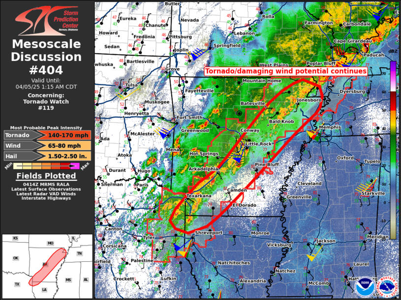
   Mesoscale Discussion 0404
   NWS Storm Prediction Center Norman OK
   1116 PM CDT Fri Apr 04 2025

   Areas affected...Southwest/central/northeast AR and northeast
   TX/northwest LA

   Concerning...Tornado Watch 119...

   Valid 050416Z - 050615Z

   The severe weather threat for Tornado Watch 119 continues.

   SUMMARY...Tornado/damaging wind potential continues particularly
   across central/northeast Arkansas including the Little Rock
   vicinity. Tornado Watch 119 continues until 4am CDT/09z.

   DISCUSSION...Several embedded supercells/small-scale bows continue
   especially across central Arkansas including near the Little Rock
   metro area as of 1110pm CDT, commonly favoring areas along/north of
   shallow prior outflow emanating from the north. The potential for
   tornadoes, along with damaging winds, continues particularly in a
   southwest/northeast-oriented corridor across central to northeast
   Arkansas. This is attributable to a moist low-level environment and
   strong low-level shear/SRH, with upwards of 250-400 m2/s2 0-1km SRH
   based on regional WSR-88D VWP data.

   ..Guyer.. 04/05/2025

   ...Please see www.spc.noaa.gov for graphic product...

   ATTN...WFO...MEG...LZK...SHV...

   LAT...LON   32879449 33859364 34259306 35869151 36449048 36268996
               35738995 35079073 32749340 32879449

   MOST PROBABLE PEAK TORNADO INTENSITY...140-170 MPH
   MOST PROBABLE PEAK WIND GUST...65-80 MPH
   MOST PROBABLE PEAK HAIL SIZE...1.50-2.50 IN
|
|
Top/All Mesoscale Discussions/Forecast Products/Home
|
|


 @NWSSPC