|
| Mesoscale Discussion 405 |
|
< Previous MD Next MD >
|
|
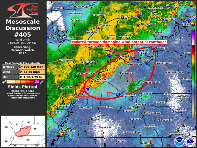
   Mesoscale Discussion 0405
   NWS Storm Prediction Center Norman OK
   1135 PM CDT Fri Apr 04 2025

   Areas affected...Western/central Kentucky and far southern Indiana

   Concerning...Tornado Watch 120...

   Valid 050435Z - 050630Z

   The severe weather threat for Tornado Watch 120 continues.

   SUMMARY...Damaging wind/tornado potential will continue, at least on
   isolated basis, mainly across western Kentucky into the overnight,
   and possibly east-northeastward into parts of central Kentucky/far
   southern Indiana. Tornado Watch 120 continues until 4am CDT/09z, and
   downstream convective trends will continue to be monitored, although
   the need for an additional Watch is uncertain.

   DISCUSSION...Line Echo Wave Pattern (LEWP) evolution continues to
   occur with multiple bowing segments across western Kentucky into
   southwest Indiana, including one of the bow echoes preferentially
   favoring and riding along prior outflow east of the Paducah area as
   of 1130pm CDT. Near the terminus of the strong regional low-level
   jet, low-level shear is robust within this corridor with 0-1km SRH
   on the order of 250-400 m2/s2. Damaging wind along with some tornado
   potential will continue especially across western Kentucky over the
   next couple of hours. Overall storm intensity should gradually
   diminish overnight as storms progress eastward, but at least a
   lower-end damaging wind/tornado risk could breach the current
   Tornado Watch, and convective trends will continue to be monitored.

   ..Guyer.. 04/05/2025

   ...Please see www.spc.noaa.gov for graphic product...

   ATTN...WFO...LMK...OHX...PAH...MEG...

   LAT...LON   36428807 36528886 37008909 38008752 38368602 37918580
               37418594 37018622 36658692 36428807

   MOST PROBABLE PEAK TORNADO INTENSITY...100-130 MPH
   MOST PROBABLE PEAK WIND GUST...65-80 MPH
   MOST PROBABLE PEAK HAIL SIZE...1.00-1.75 IN
|
|
Top/All Mesoscale Discussions/Forecast Products/Home
|
|


 @NWSSPC