|
| Mesoscale Discussion 182 |
|
< Previous MD Next MD >
|

|
   Mesoscale Discussion 0182
   NWS Storm Prediction Center Norman OK
   0921 PM CDT Fri Mar 14 2025

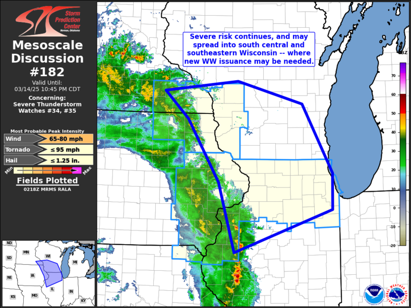
   Areas affected...southeastern Minnesota...far eastern
   Iowa...northern Illinois...and southern Wisconsin

   Concerning...Severe Thunderstorm Watch 34...35...

   Valid 150221Z - 150345Z

   The severe weather threat for Severe Thunderstorm Watch 34, 35
   continues.

   SUMMARY...Local risk for damaging wind gusts continues, and may
   spread into parts of southern Wisconsin east of WW 34.  This may
   require new WW issuance.

   DISCUSSION...Latest radar loop shows a band of generally weak
   convection from a reflectivity perspective, moving northeastward
   across parts of southern Minnesota and eastern Iowa, and into
   northwestern Illinois.  Despite the weak reflectivity structure, the
   still-dry sub-cloud layer in tandem with very strong flow aloft
   ahead of the advancing upper low suggests conditions supportive of
   locally strong wind gusts.  Thus -- expect local potential for
   damaging winds to continue over the next couple of hours across
   portions of WW 34 and 35, and eventually portions of southern
   Wisconsin outside of these watches.  A new WW issuance may be needed
   soon, to highlight this potential into southeastern Wisconsin.

   ..Goss.. 03/15/2025

   ...Please see www.spc.noaa.gov for graphic product...

   ATTN...WFO...GRB...LOT...ILX...MKX...DVN...ARX...

   LAT...LON   43389197 43999266 44219049 43708856 42198770 41398772
               40469057 42009104 43389197
|
|
Top/All Mesoscale Discussions/Forecast Products/Home
|
|


