Mesoscale Discussion 0173
NWS Storm Prediction Center Norman OK
0501 PM CDT Fri Mar 14 2025
Areas affected...eastern Nebraska...Iowa...southern
Minnesota...southwestern Wisconsin...and northwestern Illinois
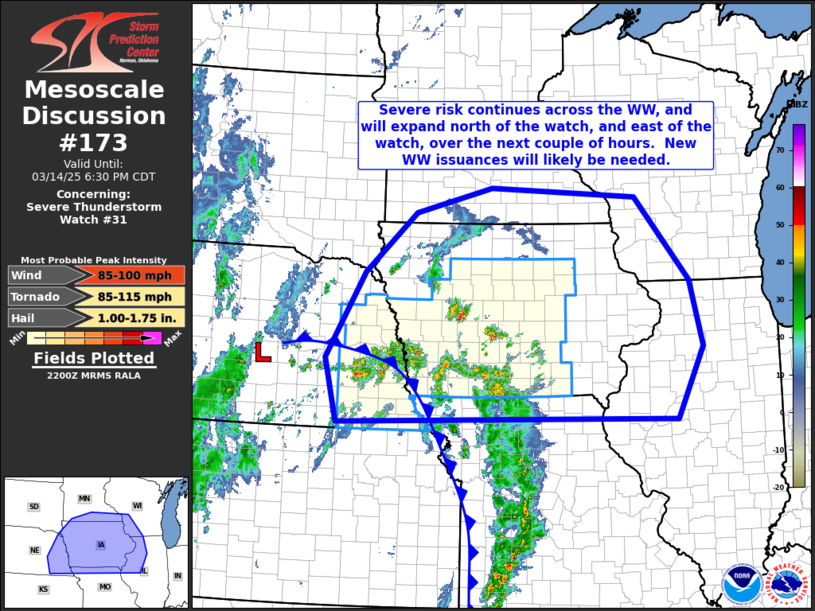
Concerning...Severe Thunderstorm Watch 31...
Valid 142201Z - 142330Z
The severe weather threat for Severe Thunderstorm Watch 31
continues.
SUMMARY...Thunderstorms are moving rapidly northward across Iowa,
where risk for strong/damaging wind gusts amd severe-caliber hail
will continue. New WW issuance will likely be required north of the
existing watch, into southern Minnesota, and -- thereafter -- east
of the watch into eastern Iowa/northwestern Illinois.
DISCUSSION...Latest radar loop shows an arcing band of strong/severe
storms extending eastward from eastern Nebraska into/across
southwestern Iowa, and then southeastward and southward across
Missouri. The west-to-east portion of the band is moving quickly
northward/north-northwestward, while the more north-south portion
across Missouri is advancing rapidly northward/north-northeastward.
A second cluster of strong/rotating storms -- north of the
west-to-east band -- is moving north-northwestward across
west-central Iowa at this time.
Greater low-level moisture (dewpoints in the 50s) exists across far
southern Missouri and into Arkansas, and is spreading northward on
strong southerly flow. However, a dry, deeply mixed boundary layer
(to around 700mb) is evident from central and northeastern Missouri
northward, with modest CAPE above the mixed layer. While
severe-caliber hail remains possible locally -- particularly with
the more isolated, west-central Iowa storms, the primary severe risk
remains very strong/damaging wind gusts -- given both the intense,
deep-layer wind field, and the sub-cloud dry air that will encourage
evaporatively enhanced downdrafts.
With the fast storm motion that is observed, severe risk will likely
begin to spread north of the existing watch (into northern Iowa and
eventually southern Minnesota) over the next hour or so. Meanwhile,
storms moving quickly north-northeastward toward/into northeastern
Missouri will also begin affecting adjacent southwestern
Iowa/northwestern Illinois -- i.e. the DVN CWA -- starting in the
next hour or so. New WW issuances will be considered in both of
these surrounding areas.
..Goss.. 03/14/2025
...Please see www.spc.noaa.gov for graphic product...
ATTN...WFO...LOT...ILX...MKX...LSX...DVN...ARX...MPX...DMX...
EAX...FSD...OAX...GID...
LAT...LON 40109740 41189767 42649683 43669568 44099397 43939069
42518949 41388921 40178981 40109740
|


 @NWSSPC