|
| Mesoscale Discussion 172 |
|
< Previous MD Next MD >
|
|
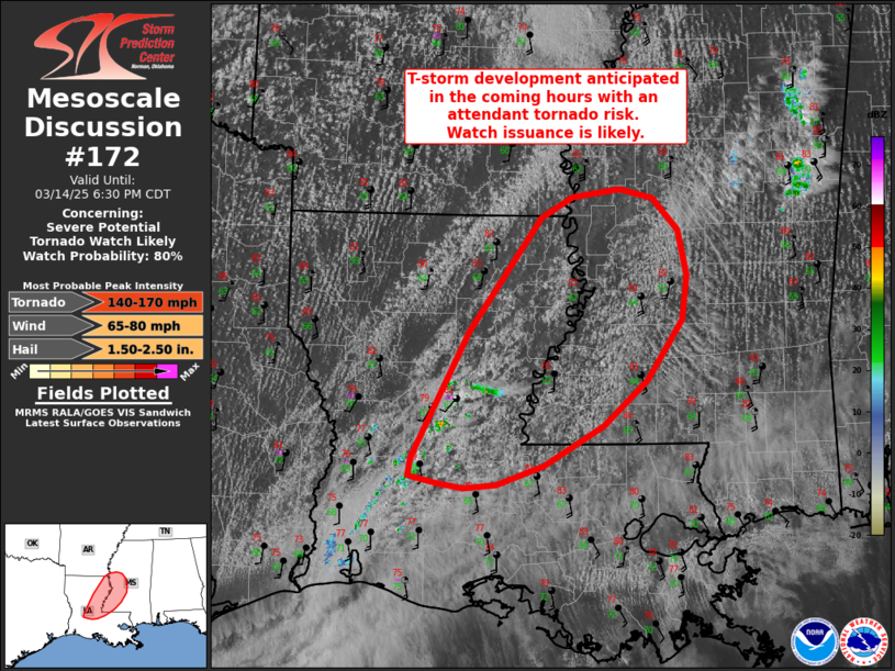
   Mesoscale Discussion 0172
   NWS Storm Prediction Center Norman OK
   0427 PM CDT Fri Mar 14 2025

   Areas affected...Eastern Louisiana into southwest Mississippi

   Concerning...Severe potential...Tornado Watch likely

   Valid 142127Z - 142330Z

   Probability of Watch Issuance...80 percent

   SUMMARY...A tornado watch will likely be needed within the next 1-2
   hours across eastern Louisiana to southwest Mississippi as
   thunderstorms develop and intensify over the region.

   DISCUSSION...Latest GOES visible and IR imagery over the past 30
   minutes has shown at least two early attempts at convective
   initiation across the Alexandria, LA area. Residual capping over the
   region is likely limited storm initiation in the short term, but a
   combination of continued low-level ascent within a subtle confluence
   axis and glancing ascent from the primary synoptic wave to the north
   (enhanced by a weak shortwave trough noted in low-level water-vapor
   imagery and 700 mb analyses) should continue to promote isolated to
   scattered discrete convection in the coming hours.
   Intensification/organization into robust supercells appears probable
   as convection moves into an environment characterized by
   surface-based lifted indices between -8 to -9 C across eastern LA
   into southwest MS. Veering winds through the lowest 1-2 km sampled
   in recent KDGX and KHDC VWP observations are expected to strengthen
   through the late afternoon/early evening as the low-level jet axis
   strengthens and shifts east. Consequently, a tornado threat is
   likely emerging downstream and will require watch issuance.

   ..Moore/Mosier.. 03/14/2025

   ...Please see www.spc.noaa.gov for graphic product...

   ATTN...WFO...JAN...LIX...LCH...SHV...

   LAT...LON   30889275 31989217 32989143 33179110 33249062 33159027
               32889001 32488993 32088998 31559034 31169078 30819140
               30649188 30619221 30659248 30719278 30889275
|
|
Top/All Mesoscale Discussions/Forecast Products/Home
|
|


 @NWSSPC