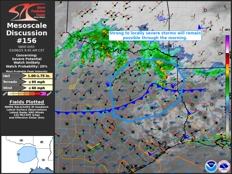
   Mesoscale Discussion 0156
   NWS Storm Prediction Center Norman OK
   0752 AM CST Sat Mar 08 2025

   Areas affected...Parts of central/northeast TX into northwest LA

   Concerning...Severe potential...Watch unlikely

   Valid 081352Z - 081545Z

   Probability of Watch Issuance...20 percent

   SUMMARY...Strong to locally severe storms remain possible through
   the morning. The southward extent of development is uncertain.

   DISCUSSION...The elevated supercells that earlier moved across parts
   of north-central into northeast TX have weakened somewhat, though a
   couple strong cells persist near the northeast Metroplex, while a
   small elevated bowing cluster is approaching the ArkLaTex region.
   The 12Z SHV/FWD soundings depict relatively cool profiles and MUCAPE
   around 500 J/kg, though both also depict weak lapse rates in a
   saturated layer above 600 mb. With effective shear remaining
   favorable for organized convection, the ongoing storms may persist
   and at least occasionally pose a localized threat of hail and strong
   gusts, before generally moving into less-favorable instability with
   eastward extent.

   Farther south, rich low-level moisture (with mid/upper 60s F) is in
   place near and south of a cold front draped from central into
   northeast TX, with MLCAPE expected to increase to 500-1000 J/kg
   later this morning. Recent HRRR runs depict storm development near
   and just south of this front later this morning into parts of
   east-central TX, possibly in response to a low-amplitude midlevel
   shortwave trough moving across central TX. Should development occur
   in this area, deep-layer shear will support organized storms, with a
   somewhat greater conditional severe potential compared to areas
   farther north. The scenario of storm development this morning near
   the front or within the warm sector remains quite uncertain, but
   will continue to be monitored.

   ..Dean/Smith.. 03/08/2025

   ...Please see www.spc.noaa.gov for graphic product...

   ATTN...WFO...SHV...HGX...FWD...

   LAT...LON   33419640 33449496 33229416 32519367 31619395 30969504
               30689662 30959736 32559761 33419640
|


 @NWSSPC