|
| Mesoscale Discussion 155 |
|
< Previous MD Next MD >
|
|
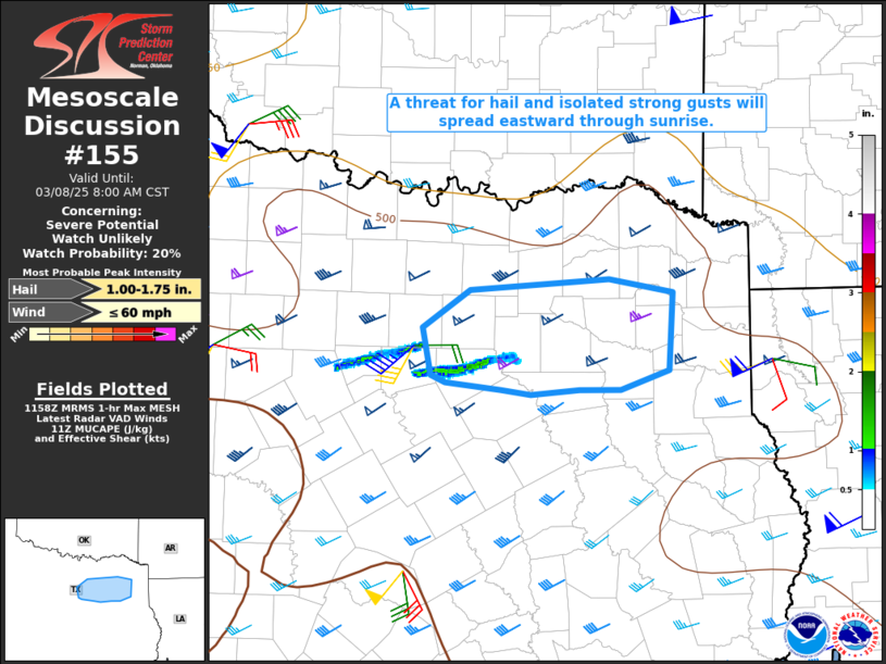
   Mesoscale Discussion 0155
   NWS Storm Prediction Center Norman OK
   0559 AM CST Sat Mar 08 2025

   Areas affected...Parts of north-central into northeast TX

   Concerning...Severe potential...Watch unlikely

   Valid 081159Z - 081400Z

   Probability of Watch Issuance...20 percent

   SUMMARY...A threat for hail and locally strong gusts will spread
   from north-central into northeast Texas through sunrise.

   DISCUSSION...A pair of long-lived, elevated supercells are moving
   across southern portions of the Metroplex early this morning, with
   MRMS data suggesting these cells have produced long swaths of
   subsevere to occasionally severe hail. Strong flow above 3 km (as
   noted on the KFWS VWP) will continue to support sufficient effective
   shear for storm organization as these cells move quickly
   east-northeastward through and after sunrise.

   MUCAPE of 500-1000 J/kg and relatively cold temperatures aloft will
   continue to provide a favorable thermodynamic profile for hail with
   these cells, though generally limited storm depth (with echo tops
   generally below 35 kft) may continue to limit the maximum hail sizes
   to some extent. Strong gusts will also continue to be possible with
   these cells, as noted earlier with a 42 kt gust in Cleburne.

   ..Dean/Smith.. 03/08/2025

   ...Please see www.spc.noaa.gov for graphic product...

   ATTN...WFO...SHV...FWD...

   LAT...LON   32719722 33029675 33129540 33009479 32379483 32219529
               32219570 32169617 32209646 32269699 32339713 32719722
|
|
Top/All Mesoscale Discussions/Forecast Products/Home
|
|


 @NWSSPC