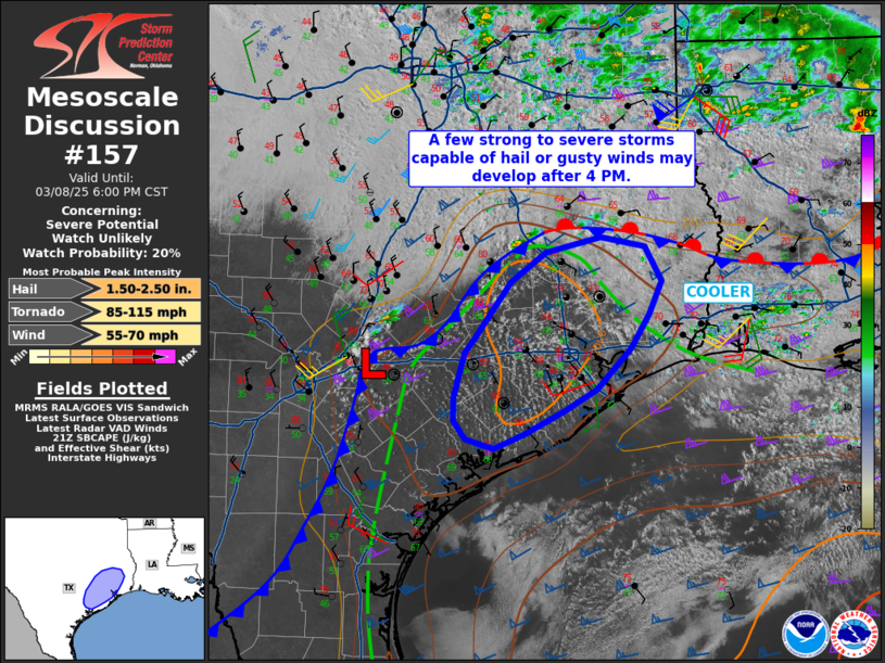
   Mesoscale Discussion 0157
   NWS Storm Prediction Center Norman OK
   0323 PM CST Sat Mar 08 2025

   Areas affected...southeast Texas

   Concerning...Severe potential...Watch unlikely

   Valid 082123Z - 090000Z

   Probability of Watch Issuance...20 percent

   SUMMARY...A few strong storms are expected to develop over the next
   few hours, with isolated large hail or gusty winds possible.

   DISCUSSION...A weak surface low is present south of the Austin TX
   area, where a cold front approaching from the west is intersecting
   the southward surging boundary. The eastern portion of the boundary
   extends across the Sabine River and into southern LA, with
   substantial clouds and cooler temperatures within that zone.

   Southerly winds across the warm sector have led to around 1500 J/kg
   MLCAPE, with temperatures in the 80s F and dewpoints mixed into the
   upper 60s F. Deep-layer shear is robust at over 60 kt, with lengthy
   hodographs. Low-level winds are relatively weak, but modest SRH
   values exist near the warm advection zone east of Houston.

   Visible imagery shows deepening CU fields around Houston, indicative
   of a moist deepening boundary layer, and showers are beginning to
   show on radar. As the cold front pushes into the area and interacts
   with the unstable air mass near peak heating, at least isolated
   cells are anticipated.  Good lapse rates aloft and strong deep shear
   will support hail. A conditional damaging wind or even brief tornado
   risk could potentially occur with any storm that remains situated
   along the cold front/warm front intersection north/east of Houston,
   but any such threat should remain localized.

   ..Jewell/Bunting.. 03/08/2025

   ...Please see www.spc.noaa.gov for graphic product...

   ATTN...WFO...LCH...HGX...EWX...

   LAT...LON   30819565 30979498 30879446 30529426 30179440 29829462
               29399504 29169542 28939588 28769627 28869661 29059674
               29309674 29769662 29889653 30509606 30819565
|


 @NWSSPC