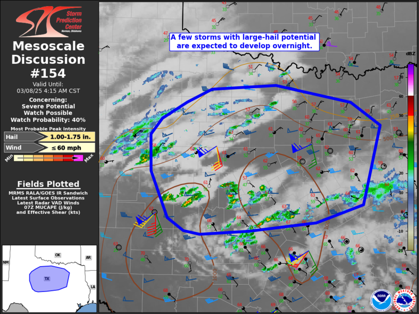
   Mesoscale Discussion 0154
   NWS Storm Prediction Center Norman OK
   0149 AM CST Sat Mar 08 2025

   Areas affected...Parts of northwest into north TX

   Concerning...Severe potential...Watch possible

   Valid 080749Z - 081015Z

   Probability of Watch Issuance...40 percent

   SUMMARY...A few storms with large-hail potential are expected to
   develop overnight.

   DISCUSSION...Weak elevated convection is ongoing early this morning
   across parts of central TX, with a recent increase in midlevel
   cloudiness and elevated convection also noted across northwest TX.
   This ongoing activity is likely related to ascent and midlevel
   moistening beneath steepening midlevel lapse rates, in advance of a
   mid/upper-level low (and related shortwave trough) approaching the
   region from the southern Rockies. A further increase in elevated
   convection is expected overnight, primarily near/north of a
   southward-moving cold front, as relatively rich low-level moisture
   continues to stream northward near/north of the frontal zone, and
   ascent related to the shortwave and attendant strong mid/upper-level
   jet overspreads the region.

   While ongoing weak convection may be rooted near/above 700 mb,
   continued low-level moistening beneath steepening midlevel lapse
   rates is expected to result in a few deeper/stronger elevated storms
   overnight, especially from parts of northwest into north TX. MUCAPE
   increasing to near/above 1000 J/kg and favorable effective shear
   could support at least transient elevated supercells, with some CAM
   guidance suggesting development of one or two longer-lived cells
   later this morning.

   Cold temperatures aloft and steep midlevel lapse rates will support
   a hail threat with the stronger elevated storms, especially if any
   deeper and longer-lived cells can develop. Locally gusty winds could
   also accompany any sustained supercells, despite the elevated nature
   of the convection. Coverage and longevity of the organized severe
   threat remain uncertain, but watch issuance may be considered if
   observational trends support maintenance of multiple severe storms
   overnight.

   ..Dean/Smith.. 03/08/2025

   ...Please see www.spc.noaa.gov for graphic product...

   ATTN...WFO...FWD...OUN...SJT...LUB...

   LAT...LON   32080059 32720061 33000038 33309987 33539935 33599803
               33289647 32889587 31499625 31199721 31059857 31009957
               31069990 31280023 32080059
|


 @NWSSPC