|
| Mesoscale Discussion 136 |
|
< Previous MD Next MD >
|
|
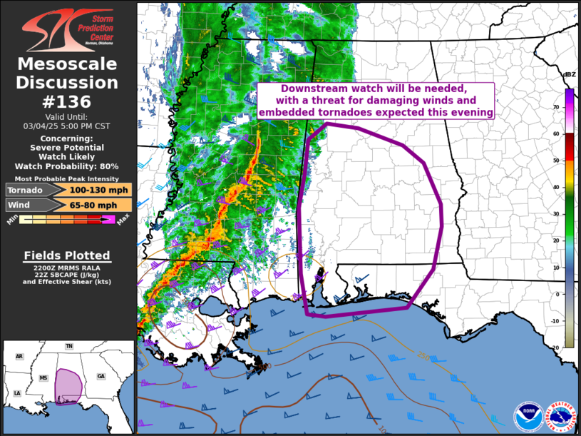
   Mesoscale Discussion 0136
   NWS Storm Prediction Center Norman OK
   0402 PM CST Tue Mar 04 2025

   Areas affected...portions of southern Alabama and the Florida
   panhandle

   Concerning...Severe potential...Watch likely

   Valid 042202Z - 042300Z

   Probability of Watch Issuance...80 percent

   SUMMARY...A downstream watch will be needed with a threat for
   damaging gusts and embedded tornadoes across portions of southern
   Alabama and the Florida panhandle.

   DISCUSSION...A strongly-forced line of convection is ongoing this
   afternoon across portions of southeastern Louisiana and central
   Mississippi. Moisture ahead of the line has been relatively meager,
   with modified continental air mass in place across southern Alabama
   and the Florida panhandle yielding surface dewpoints largely in the
   50s to low 60s F. As the line approaches from the west, the
   low-level mass response is expected to turn the winds more
   southerly, bringing higher moisture onshore and at least some
   positive buoyancy. The 21Z KLIX sounding shows the effect of this
   with a deep moist adiabatic layer near the surface resulting in
   meager CAPE values.

   Given the very strong low-level flow in that sounding and on VWPs
   across the region, and despite the poor low-level lapse rates,
   convection is expected to mix some of that flow down to the surface
   producing a threat for damaging gusts. In addition, given the strong
   low-level shear, some mesovortex-type tornadoes are possible in the
   line as the line moves to the east with time.

   ..Supinie/Mosier.. 03/04/2025

   ...Please see www.spc.noaa.gov for graphic product...

   ATTN...WFO...TAE...BMX...MOB...

   LAT...LON   30068783 30098821 30828836 31998841 32598830 33228824
               33508785 33428717 33118622 32808578 32058544 31668543
               30898561 30218616 30068783
|
|
Top/All Mesoscale Discussions/Forecast Products/Home
|
|


 @NWSSPC