|
| Mesoscale Discussion 135 |
|
< Previous MD Next MD >
|
|
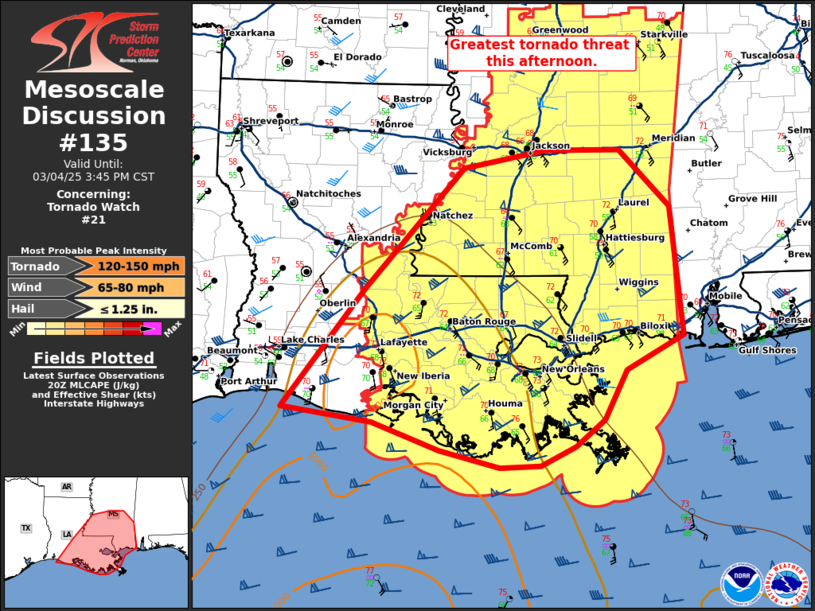
   Mesoscale Discussion 0135
   NWS Storm Prediction Center Norman OK
   0214 PM CST Tue Mar 04 2025

   Areas affected...southern Mississippi and southern Alabama

   Concerning...Tornado Watch 21...

   Valid 042014Z - 042145Z

   The severe weather threat for Tornado Watch 21 continues.

   SUMMARY...The greatest tornado threat this afternoon will be across
   southern Mississippi and southern Louisiana.

   DISCUSSION...The warm sector is slowly expanding eastward across
   southern Mississippi with upper 60s dewpoints now across southern
   Louisiana. Thunderstorms development continues along and slightly
   ahead of a cold front extending from near the ArkLaMiss to the
   central Louisiana Gulf Coast. A few embedded supercells have
   produced transient circulations and some severe wind gusts, but a
   strong, mature supercell has yet to form. This remains a possibility
   this afternoon as convection continues to develop and slowly deepen
   across southern Louisiana and Mississippi. The supercell tornado
   threat this afternoon will increase if a large enough area of
   greater instability (1000-1500 J/kg MLCAPE) can develop. However,
   this is seemingly less likely as eastward warm sector expansion
   remains slow with expansive cloud cover. Nonetheless, even without
   mature supercells, a damaging wind and embedded tornado threat will
   continue through the afternoon and into the evening with very strong
   low-level flow (70 knots at 1.5 km per JAN 19Z RAOB).

   ..Bentley.. 03/04/2025

   ...Please see www.spc.noaa.gov for graphic product...

   ATTN...WFO...MOB...JAN...LIX...LCH...

   LAT...LON   29619317 30849219 32139099 32328998 32328908 31728847
               30368833 30008902 29488928 29208963 29009006 28989055
               29169128 29469208 29619317
|
|
Top/All Mesoscale Discussions/Forecast Products/Home
|
|


 @NWSSPC