|
| Mesoscale Discussion 129 |
|
< Previous MD Next MD >
|
|
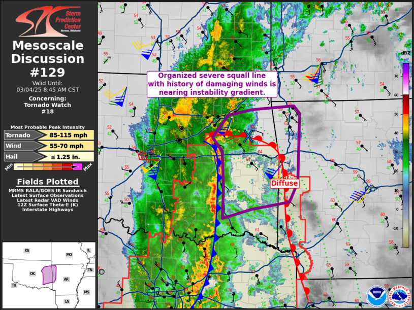
   Mesoscale Discussion 0129
   NWS Storm Prediction Center Norman OK
   0622 AM CST Tue Mar 04 2025

   Areas affected...eastern Oklahoma into far western Arkansas

   Concerning...Tornado Watch 18...

   Valid 041222Z - 041445Z

   The severe weather threat for Tornado Watch 18 continues.

   SUMMARY...A squall line with history of damaging winds may remain
   severe as it approaches the Arkansas border.

   DISCUSSION...Surface analysis shows a warm front remains over
   northeast OK and extending southward roughly near the OK/AR border.
   Pressure falls are currently strong in this region with over 2 mb
   falls per hour noted. As such, it is likely that the low-level jet
   is transporting higher theta-e air northward, perhaps just off the
   surface. Therefore, while surface observations otherwise indicate
   weak/marginal instability extending into the northwest AR area, it
   is not inconceivable that the line remains severe into those areas
   with damaging wind potential.

   Depending on storm trends, an additional small watch cannot be ruled
   out.

   ..Jewell.. 03/04/2025

   ...Please see www.spc.noaa.gov for graphic product...

   ATTN...WFO...LZK...SHV...TSA...OUN...

   LAT...LON   34919399 34539419 34389508 34209577 34819575 35529579
               35799602 36229565 36349505 36409407 36259392 34919399
|
|
Top/All Mesoscale Discussions/Forecast Products/Home
|
|


 @NWSSPC