|
| Mesoscale Discussion 128 |
|
< Previous MD Next MD >
|
|
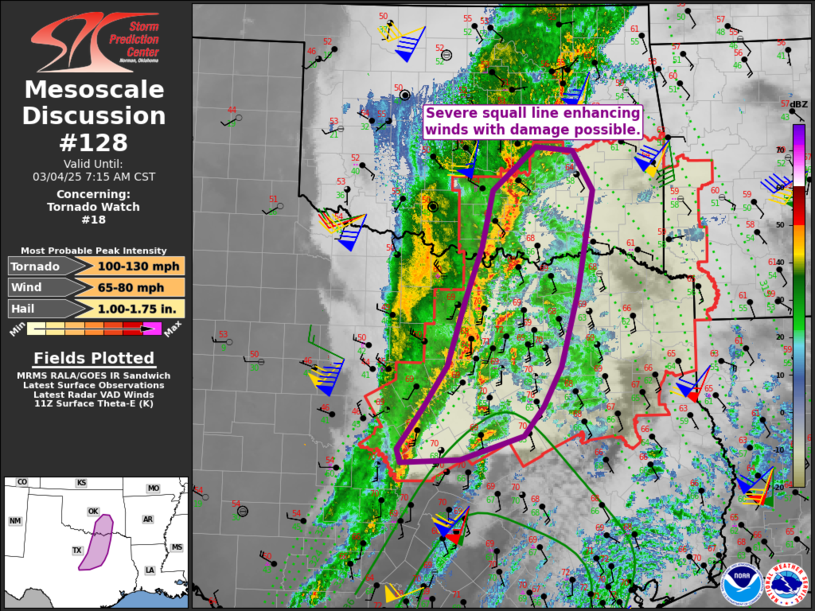
   Mesoscale Discussion 0128
   NWS Storm Prediction Center Norman OK
   0513 AM CST Tue Mar 04 2025

   Areas affected...north Texas into southeast Oklahoma

   Concerning...Tornado Watch 18...

   Valid 041113Z - 041315Z

   The severe weather threat for Tornado Watch 18 continues.

   SUMMARY...Damaging winds likely to persist across north Texas into
   southeast Oklahoma. A brief tornado remains possible as well.

   DISCUSSION...A squall line has gained strength and speed over the
   past few hours, and will continue to push east across northern TX
   and southeastern OK. Widespread strong to damaging winds are likely,
   with substantial/cold downdrafts augmenting the already strong
   boundary-layer wind gusts well ahead of the line.

   Recently, a gradually deepening line of convection was noted near
   Waco, stretching north and intersecting the squall line as it moves
   into the Metroplex. This intersection may prove favorable for
   enhanced severe winds over 75 mph, along with stronger cyclonic
   shear. Given the continued push to the shortwave trough and strong
   low-level jet, this line should remain severe for several more
   hours.

   ..Jewell.. 03/04/2025

   ...Please see www.spc.noaa.gov for graphic product...

   ATTN...WFO...TSA...FWD...OUN...

   LAT...LON   31599658 31309751 31259839 31429844 31959805 32479772
               33319745 33969720 34689705 35239640 35189583 34679553
               33429577 32459603 31969629 31599658
|
|
Top/All Mesoscale Discussions/Forecast Products/Home
|
|


 @NWSSPC