|
| Mesoscale Discussion 124 |
|
< Previous MD Next MD >
|
|
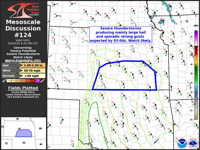
   Mesoscale Discussion 0124
   NWS Storm Prediction Center Norman OK
   0713 PM CST Mon Mar 03 2025

   Areas affected...portions of south-central and southeast Kansas

   Concerning...Severe potential...Severe Thunderstorm Watch likely

   Valid 040113Z - 040245Z

   Probability of Watch Issuance...95 percent

   SUMMARY...Severe thunderstorms posing main a risk for large hail and
   isolated damaging wind gusts are expected to develop by 03-04z. A
   severe thunderstorm watch will likely be needed for portions of
   south-central and southeast Kansas in the next hour or so.

   DISCUSSION...Low-level warm advection across OK/TX into southern KS
   will persist through the evening and overnight hours ahead of an
   eastward-advancing surface low (currently centered over southeast
   CO) and attendant cold front. 00z regional RAOBs from DDC and OUN
   indicate a robust warm layer/cap atop a cool boundary layer, similar
   to forecast sounding guidance. Strong large-scale ascent associated
   with the ejecting upper low/shortwave trough and linear forcing
   related to the advancing cold front will act to weak inhibition
   some. However, convection developing by 03-04z is expected to
   largely remain elevated given a lack of a warmer/more moist boundary
   layer.

   Nevertheless, steep midlevel lapse rates (500 mb temps around -17 to
   -16 C) will support MUCAPE around 1000-2000 J/kg. Strong deep layer
   flow with effective shear magnitudes greater than 35 kt will
   likewise foster organized convection. An elevated line of
   convection, perhaps mixed with some cellular elements, will sweep
   across south-central/southeast KS during the evening to overnight
   hours. Initial convection within the first couple of hours will pose
   a greater risk for large hail if storm mode can maintain cellular
   characteristics. Otherwise, some risk for isolated damaging gusts
   also will be possible even with elevated storm given strong
   low-level flow and restively quick storm motion.

   While the elevated nature of convection is expected to limit tornado
   potential across Kansas, low-level wind profiles are quite favorable
   for rotation. While a brief spin-up cannot be ruled out, the overall
   tornado risk is expected to remain secondary to large hail and
   strong gust potential.

   ..Leitman/Guyer.. 03/04/2025

   ...Please see www.spc.noaa.gov for graphic product...

   ATTN...WFO...TOP...ICT...DDC...

   LAT...LON   37019924 38089885 38289840 38429736 38399619 37899546
               37009539 37019924
|
|
Top/All Mesoscale Discussions/Forecast Products/Home
|
|


 @NWSSPC