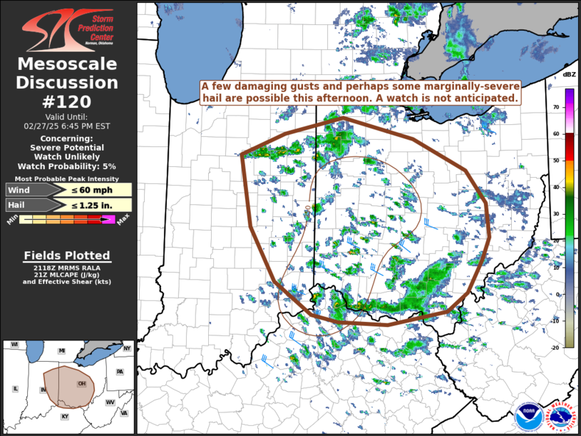
   Mesoscale Discussion 0120
   NWS Storm Prediction Center Norman OK
   0319 PM CST Thu Feb 27 2025

   Areas affected...parts of Indiana and Ohio...and far northern
   Kentucky

   Concerning...Severe potential...Watch unlikely

   Valid 272119Z - 272345Z

   Probability of Watch Issuance...5 percent

   SUMMARY...Damaging gusts and perhaps a couple marginally-severe
   hailstones are possible this afternoon across parts of Ohio, eastern
   Indiana, and far northern Kentucky. A watch is not anticipated.

   DISCUSSION...A 500 mb trough axis is situated over portions of the
   Ohio Valley this afternoon with very cold temperatures aloft
   (approximately -30 C at 500 mb per RAP analyses). This is atop a
   post-frontal air mass with surface dewpoints generally in the upper
   30s F, resulting in MLCAPE values of 300-400 J/kg with steep lapse
   rates. Convective temperature has been reached in portions of
   southwest Ohio, where low-topped convection has been ongoing, and
   additional low-topped convection is developing along a weak cold
   front across portions of northern Indiana and northwest Ohio.

   Given the steep lapse rates, low freezing level, straight hodograph,
   and the fact that most or all of the buoyancy is above the freezing
   level, a few marginally-severe hailstones may occur. The primary
   limiting factors for severe hail is expected to be the low-topped
   nature of the convection and slightly marginal deep-layer shear.
   Additionally, flow in the boundary layer is not overly strong, with
   850 mb winds of approximately 30 kts, but convection may mix that
   down to the surface and provide some enhancement to produce a few
   damaging gusts. The convection, and therefore the severe threat, is
   expected to wane later in the afternoon and evening as storms move
   to the east and east-southeast with the loss of diurnal heating.

   ..Supinie/Gleason.. 02/27/2025

   ...Please see www.spc.noaa.gov for graphic product...

   ATTN...WFO...PBZ...RLX...CLE...ILN...IWX...IND...

   LAT...LON   39168552 39928598 40938617 41238537 41478430 41178300
               40718205 40258168 39778163 39458178 39008204 38748242
               38568349 38618437 38708486 39168552
|


 @NWSSPC