|
| Mesoscale Discussion 114 |
|
< Previous MD Next MD >
|
|
Mesoscale Discussion 0114
NWS Storm Prediction Center Norman OK
1220 PM CST Tue Feb 18 2025
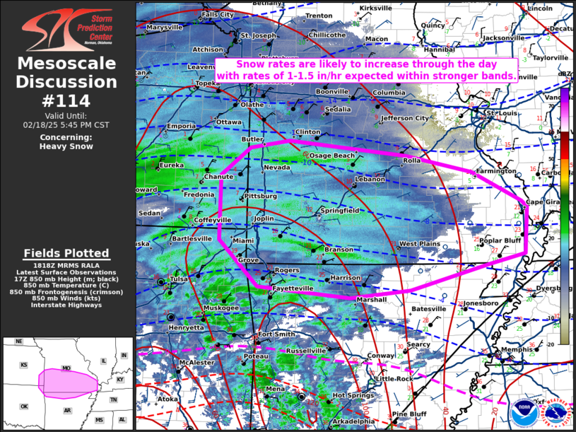
Areas affected...portions of southeastern KS...far northeastern OK
and the Ozark Plateau
Concerning...Heavy snow
Valid 181820Z - 182345Z
SUMMARY...Snowfall rates are expected to increase across portions of
eastern KS and the Ozarks over the next few hours. Rates of 1-1.5
in/hr are expected within the heavier banding.
DISCUSSION...As of 1820 UTC, regional radar and surface observations
showed a broad area of winter precipitation ongoing over the Plains
and beginning to shift eastward toward the Ozark Plateau. A
pronounced band of heavier snow has slowly coalesced over the last
couple of hours across portions of southeastern KS and northeastern
OK. Likely supported by 850-700 mb frontogenesis and isentropic
ascent, heavy snow with rates over 1" per hour have been observed.
As ascent from the upstream shortwave trough continues to intensify,
so to should the snow band as it gradually shifts eastward into
parts of MO and northern AR.
Hi-res model guidance and area RAP soundings generally agree with
observational trends and suggest strengthening of the band is likely
over the next several hours. Very cold low-level temperatures (teens
to single digits) will support efficient dendrite generation with
snow to liquid ratios in excess of 15:1. Confidence is highest that
the heavier rates will occur generally along and south of I-44
across parts of northern AR and southern MO through this evening.
..Lyons.. 02/18/2025
...Please see www.spc.noaa.gov for graphic product...
ATTN...WFO...PAH...MEG...LSX...LZK...SGF...EAX...TSA...ICT...
LAT...LON 38309384 38089168 37839048 37408956 37318946 36628951
36489018 36119161 36009271 36159440 36839512 37789510
38199456 38309384
|
|
Top/All Mesoscale Discussions/Forecast Products/Home
|
|


 @NWSSPC