|
| Mesoscale Discussion 113 |
|
Next MD >
|
|
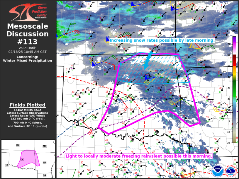
   Mesoscale Discussion 0113
   NWS Storm Prediction Center Norman OK
   0748 AM CST Tue Feb 18 2025

   Areas affected...Parts of central/eastern OK into northwest AR and
   extreme southwest MO

   Concerning...Winter mixed precipitation

   Valid 181348Z - 181645Z

   SUMMARY...Light to locally moderate freezing rain and/or sleet is
   possible this morning. Increasing snow rates are possible by late
   morning across northeast Oklahoma and vicinity.

   DISCUSSION...Light precipitation is gradually increasing this
   morning across parts of central/eastern OK, in response to warm
   advection near/above 850 mb atop a southward-advancing arctic
   airmass. The 12Z OUN sounding depicts saturation primarily below a
   notable temperature inversion around 700 mb. In the short term,
   given the relatively shallow saturated layer and lack of deeper
   ascent above this layer, a period of freezing drizzle/light freezing
   rain will be possible, with relatively efficient ice accretion in
   areas where near-surface temperatures fall through the 20s F.

   With time, deeper/stronger ascent will result in locally heavier
   precipitation rates later this morning. This may be accompanied by
   an transition to sleet and snow (especially with northward extent),
   due to continued near-surface cold advection and wet-bulb cooling of
   the initially dry layer near 700 mb. Snow rates may begin to
   increase by late morning across northeast OK and vicinity, with
   locally heavy snow possible this afternoon.

   ..Dean.. 02/18/2025

   ...Please see www.spc.noaa.gov for graphic product...

   ATTN...WFO...LZK...SGF...SHV...TSA...ICT...FWD...OUN...

   LAT...LON   35729755 36679734 37079643 37039450 36179406 34359354
               34229401 34719468 34859503 34789559 34549622 34219700
               33929779 34189828 34879786 35269768 35729755
|
|
Top/All Mesoscale Discussions/Forecast Products/Home
|
|


 @NWSSPC