|
| Mesoscale Discussion 115 |
|
< Previous MD Next MD >
|
|
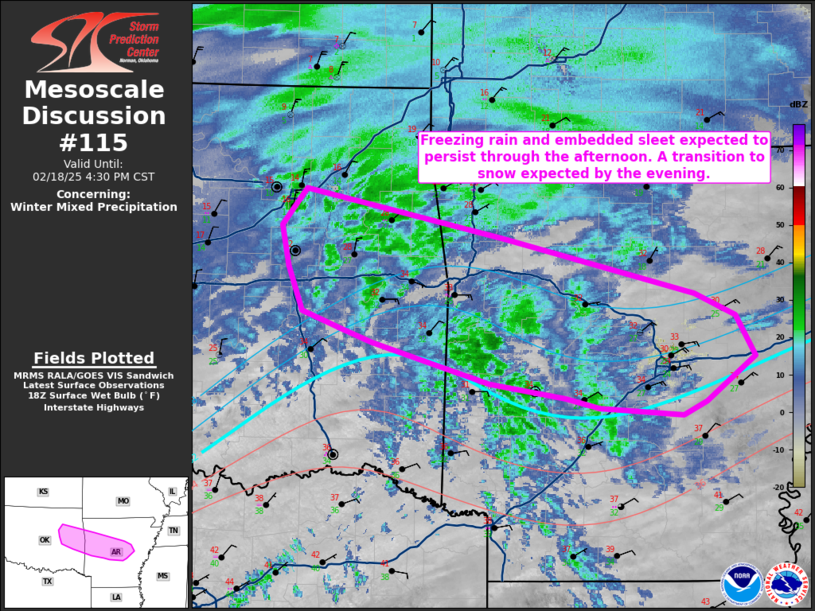
   Mesoscale Discussion 0115
   NWS Storm Prediction Center Norman OK
   1233 PM CST Tue Feb 18 2025

   Areas affected...East-central Oklahoma into central Arkansas

   Concerning...Winter mixed precipitation

   Valid 181833Z - 182230Z

   SUMMARY...Freezing rain and sleet are possible from east-central
   Oklahoma into portions of central Arkansas. Deeper cold air will
   push into the region by this evening and a transition to primarily
   snow is expected at that time.

   DISCUSSION...A band of precipitation driven by warm advection
   continues to increase along and near a low-level boundary. The 18Z
   observed LZK sounding showed a small increase in the strength of the
   warm nose near 800 mb as compared to the observed 12Z sounding. Some
   low-level dry air remains, but this should saturate with time. Given
   the depth of the cold air, some mix of sleet and freezing rain
   appear possible. Sleet will be more likely with any more convective
   elements as steeper mid-level lapse rates were noted on the observed
   soundings. Into southeast Oklahoma into southern Arkansas,
   temperatures are above freezing currently. Some locations could see
   temperatures at or below freezing as precipitation starts and
   diabatically cools the profile. By evening, colder air should push
   into the region and a transition to primarily snow will likely
   occur.

   ..Wendt.. 02/18/2025

   ...Please see www.spc.noaa.gov for graphic product...

   ATTN...WFO...LZK...TSA...

   LAT...LON   34469189 34349212 34409294 34499327 34619402 34939517
               35039546 35199587 35559600 35889608 36179583 35779386
               35339200 35159161 34829141 34469189
|
|
Top/All Mesoscale Discussions/Forecast Products/Home
|
|


 @NWSSPC