|
| Mesoscale Discussion 101 |
|
< Previous MD Next MD >
|
|
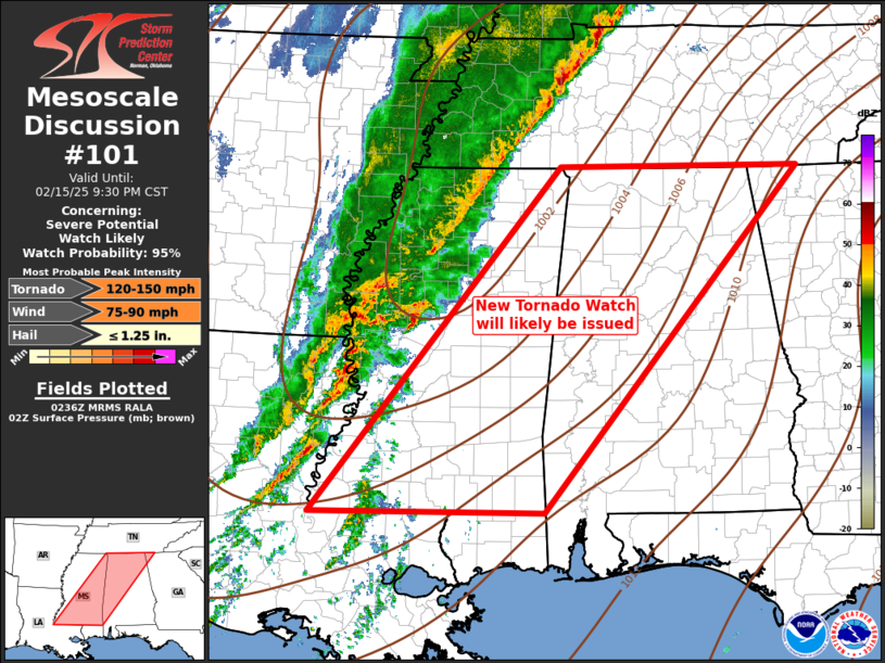
   Mesoscale Discussion 0101
   NWS Storm Prediction Center Norman OK
   0837 PM CST Sat Feb 15 2025

   Areas affected...Central Gulf States

   Concerning...Severe potential...Watch likely

   Valid 160237Z - 160330Z

   Probability of Watch Issuance...95 percent

   SUMMARY...New Tornado Watch will be issued across the central Gulf
   States by 0330z.

   DISCUSSION...Fast-moving upper trough is ejecting across eastern
   OK/TX and the associated cold front is surging through the lower MS
   Valley region, currently stretching from eastern AR into
   south-central TX. An expansive corridor of pre-frontal convection
   has developed ahead of the short wave from the lower OH Valley,
   southwest into central LA. Over the last hour or so, thunderstorm
   activity appears to be gradually sharpening across the lower MS
   Valley with at least two bands of strong/severe convection that will
   soon spread east of the MS River. Surface temperatures remain in the
   lower 70s across much of the warm sector immediately ahead of this
   activity, and mid 60s dew points have returned to central MS. While
   tornado activity has been somewhat sparse to this point, intense
   0-3km SRH warrants concern. Latest thinking is updrafts may continue
   to mature and longer-lived supercells are certainly possible, though
   an organized QLCS will be the primary storm mode. This MCS will
   advance across the remainder of the central Gulf States later
   tonight.

   ..Darrow/Hart.. 02/16/2025

   ...Please see www.spc.noaa.gov for graphic product...

   ATTN...WFO...MRX...FFC...OHX...BMX...HUN...MOB...MEG...JAN...
   LIX...

   LAT...LON   30999162 35018822 34998491 30998843 30999162
|
|
Top/All Mesoscale Discussions/Forecast Products/Home
|
|


 @NWSSPC