|
| Mesoscale Discussion 99 |
|
< Previous MD Next MD >
|
|
Mesoscale Discussion 0099
NWS Storm Prediction Center Norman OK
0549 PM CST Sat Feb 15 2025
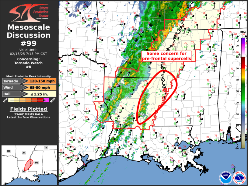
Areas affected...Lower Mississippi Valley
Concerning...Tornado Watch 8...
Valid 152349Z - 160115Z
The severe weather threat for Tornado Watch 8 continues.
SUMMARY...Pre-frontal supercells may mature over the next few hours
as they track across northeast LA into west-central MS. Tornado risk
will increase if this occurs. Will continue to monitor for possible
Tornado Watch immediately downstream into Mississippi.
DISCUSSION...Over the last hour or so, pre-frontal convection has
gradually increased across central into northeast LA, especially
from Rapides to Caldwell Parish. This activity is not too organized
at this time but there is some concern these storms may continue to
mature within a strongly sheared environment, immediately ahead of
the frontal convection. If so, tornado risk may increase
accordingly.
..Darrow.. 02/15/2025
...Please see www.spc.noaa.gov for graphic product...
ATTN...WFO...JAN...LCH...SHV...
LAT...LON 32219222 33319116 32579049 31089223 32219222
|
|
Top/All Mesoscale Discussions/Forecast Products/Home
|
|


 @NWSSPC