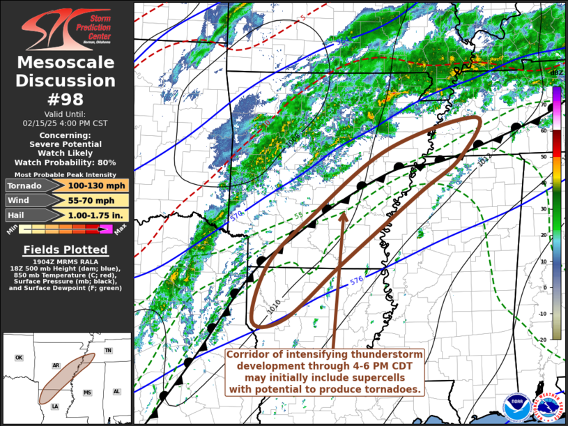
   Mesoscale Discussion 0098
   NWS Storm Prediction Center Norman OK
   0106 PM CST Sat Feb 15 2025

   Areas affected...parts of southern and eastern Arkansas and adjacent
   portions of northwestern Louisiana...northwestern Mississippi and
   western Tennessee

   Concerning...Severe potential...Watch likely

   Valid 151906Z - 152200Z

   Probability of Watch Issuance...80 percent

   SUMMARY...A corridor of intensifying thunderstorm development
   appears likely east of the Ark-La-Tex northeastward toward the
   Greater Memphis vicinity through 4-6 PM CDT.  Initially this may
   include a risk for supercells with potential to produce tornadoes,
   before storms consolidate into an organizing line.

   DISCUSSION...A baroclinic zone on the northwestern periphery of
   warm, moist southerly return flow from the western Gulf has been
   reinforced by persistent warm advection driven weak convective
   development.  Differential heating is contributing to strengthening
   of the thermal gradient, and a slow northward advancement of the
   front at the surface, toward the Memphis TN, Pine Bluff and El
   Dorado AR vicinities.  Surface observations indicate that a focused
   area of stronger surface pressure falls (2-3+ mb/2 hourly) is
   already developing to the west/northwest of Little Rock as of 18Z,
   and models indicate that this boundary will become the focus for
   strengthening surface cyclogenesis later this afternoon into
   tonight.

   Upstream, it appears that a significant approaching short wave
   trough will maintain a general positive tilt as it progresses
   eastward across the southern Great Plains into early evening.
   However, models suggest that increasingly difluent/divergent flow
   ahead of it will contribute to increasing forcing for ascent along
   the frontal zone by 21-23Z.

   Although it is possible that this may remain largely focused
   above/just to the cool side of the front, there may be a window of
   opportunity for sufficient weakening of mid-level inhibition, in a
   narrow corridor just ahead of the front, to support thunderstorm
   initiation rooted within an unstable boundary-layer characterized by
   CAPE up to 1000 J/kg.  Within this regime, low-level hodographs,
   beneath 50+ kt south-southwesterly flow around 850 mb, are already
   sizable and clockwise curved, and conducive to the evolution of
   strong low-level mesocyclones with the potential to produce
   tornadoes.

   ..Kerr/Smith.. 02/15/2025

   ...Please see www.spc.noaa.gov for graphic product...

   ATTN...WFO...MEG...JAN...LZK...SHV...

   LAT...LON   35129106 35688911 34958950 34329039 33089205 32119322
               32039392 33049363 33889275 35129106
|


 @NWSSPC