|
| Mesoscale Discussion 97 |
|
< Previous MD Next MD >
|
|
Mesoscale Discussion 0097
NWS Storm Prediction Center Norman OK
1150 AM CST Sat Feb 15 2025
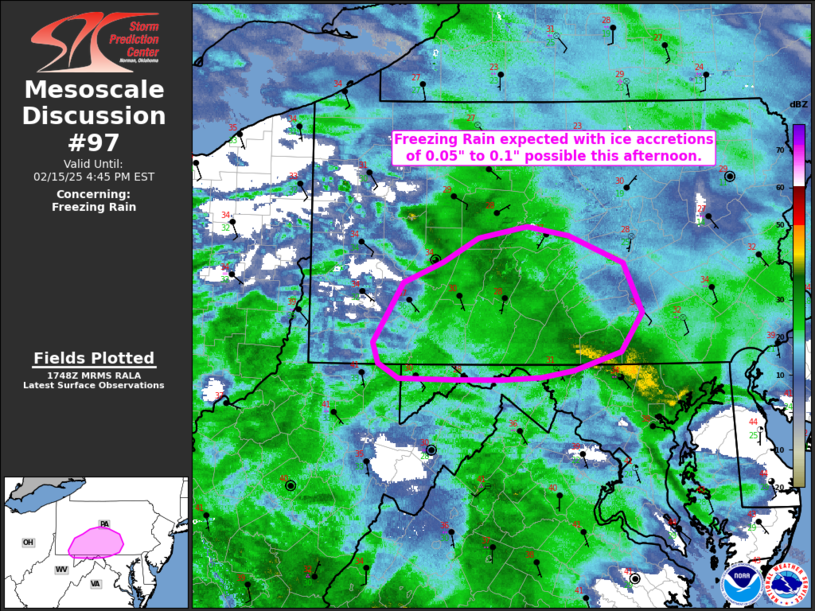
Areas affected...parts of southern Pennsylvania and northwest
Maryland
Concerning...Freezing rain
Valid 151750Z - 152145Z
SUMMARY...Freezing rain is expected with ice accretion of 0.05" to
0.1" is possible this afternoon across parts of south-central
Pennsylvania and adjacent areas of Maryland.
DISCUSSION...A broad area of low-level warm advection across the
mid-Atlantic states is providing the lift for widespread
precipitation occurring across the region. The transition zone from
snow across the northern parts of the region to rain across the
southern parts is currently across southwestern Pennsylvania into
northeastern West Virginia, which should generally lift
northeastward with time. The advance of the warmer mid-level air is
apparent on KCCX radar with lowered correlation coefficient
indicating melting of hydrometeors. However, the surface cold air
has been slow to erode, with parts of south-central Pennsylvania and
adjacent areas of Maryland remaining below freezing at the surface.
A couple surface sites across south-central Pennsylvania and
adjacent areas of West Virginia and Maryland are reporting unknown
precip with temperatures below freezing, likely indicating a
transition to freezing rain has begin.
NAM forecast profiles this afternoon across parts of the region show
classic freezing rain conditions, with a shallow layer of
below-freezing air with a large warm nose aloft. One potential
mitigating factor for ice accretion is that surface wet-bulb
temperatures generally hover in the 30-32 F range, which is marginal
for significant ice accretion. With time, expect the low-level cold
air to erode and transition to all rain later this afternoon as the
precipitation ends from west to east.
..Supinie.. 02/15/2025
...Please see www.spc.noaa.gov for graphic product...
ATTN...WFO...CTP...LWX...PBZ...
LAT...LON 39907979 40427946 40617901 40827861 40917805 40837758
40607696 40177676 39837700 39677752 39617790 39597834
39587885 39607951 39727974 39907979
|
|
Top/All Mesoscale Discussions/Forecast Products/Home
|
|


 @NWSSPC