|
| Mesoscale Discussion 96 |
|
< Previous MD Next MD >
|
|
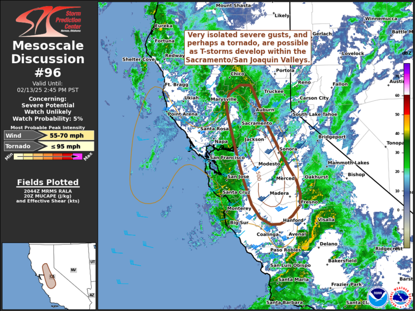
   Mesoscale Discussion 0096
   NWS Storm Prediction Center Norman OK
   0246 PM CST Thu Feb 13 2025

   Areas affected...The Sacramento and San Joaquin Valleys in central
   California

   Concerning...Severe potential...Watch unlikely

   Valid 132046Z - 132245Z

   Probability of Watch Issuance...5 percent

   SUMMARY...Sporadic thunderstorms are expected to develop through the
   afternoon hours within the Sacramento and San Joaquin Valleys in
   central California. Stronger/deeper storms will be capable of
   isolated severe gusts, and perhaps a tornado given sufficient
   low-level wind shear.

   DISCUSSION...Isolated deep convection has been gradually developing
   within the southern Sacramento/northern San Joaquin Valley over the
   past hour or so. These storms have developed within a small pocket
   where cloud breaks have allowed surface temperatures to warm into
   the upper 50s and low 60s, which are required to support deep,
   surface-based convection. Overall, poor mid-level lapse rates are
   limiting (and will continue to limit) buoyancy with maximum MUCAPE
   values of around 250-500 J/kg noted in recent mesoanalysis
   estimates. However, strong deep-layer wind shear (effective bulk
   shear of around 40-45 knots) is in place across the region as a
   mid-level jet associated with an approaching upper wave overspreads
   the region. Additionally, backed low-level flow within the valley is
   supporting 0-1 km SRH values on the order of about 100 m2/s2. As a
   result, organization of deeper, longer lived cells appears possible
   with an attendant threat of severe winds and perhaps a brief tornado
   (small hail is also possible, but the limited buoyancy and duration
   of individual cells casts uncertainty on the severe hail potential).
   This threat will likely be confined to the valleys and is expected
   to be too sporadic/isolated to warrant watch issuance.

   ..Moore/Thompson.. 02/13/2025

   ...Please see www.spc.noaa.gov for graphic product...

   ATTN...WFO...HNX...STO...MTR...

   LAT...LON   36402012 36322034 36302060 36462090 36762115 37322139
               37972161 38772186 39132192 39352182 39442168 39542152
               39542122 39392111 38672074 38092038 37612006 37321985
               37021975 36751975 36511997 36402012
|
|
Top/All Mesoscale Discussions/Forecast Products/Home
|
|


 @NWSSPC