|
| Mesoscale Discussion 95 |
|
< Previous MD Next MD >
|
|
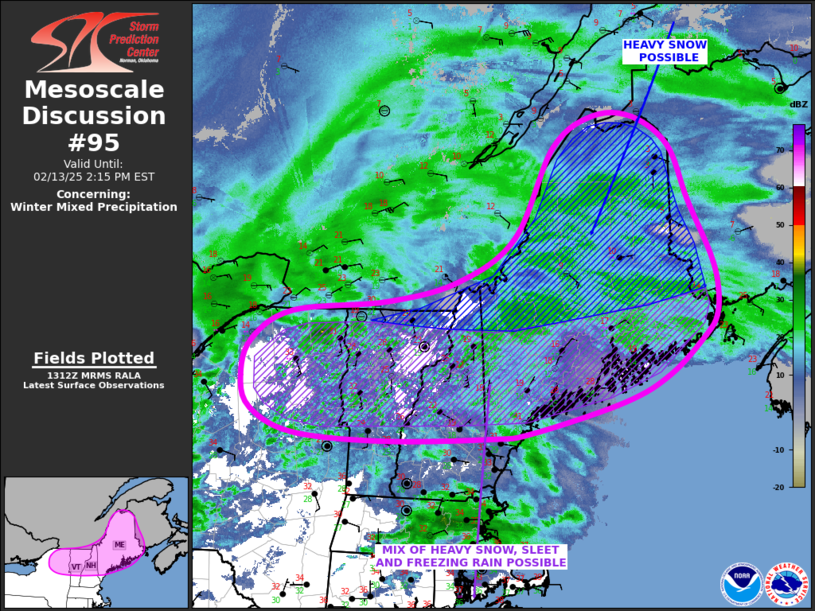
   Mesoscale Discussion 0095
   NWS Storm Prediction Center Norman OK
   0715 AM CST Thu Feb 13 2025

   Areas affected...Central and Northern New England...Northern New
   York...

   Concerning...Winter mixed precipitation

   Valid 131315Z - 131915Z

   SUMMARY...A mix of snow...sleet and freezing rain will move across
   northern New York and central New England this morning. Freezing
   rain rates could exceed 0.03 inches per hour in some areas. Heavy
   snow could develop in some areas across central and northern Maine.

   DISCUSSION...Heights will fall across the Northeast today, as a
   mid-level trough approaches from the west. Several areas of
   precipitation are ongoing in the Northeast. This is being supported
   by large-scale ascent ahead of the trough, and by strong low-level
   jet currently located in northern New York. At the surface, a strong
   thermal gradient is present with temperatures in New England ranging
   from the lower to mid 30s F over southern and central New England,
   and teens to single digits over central and northern Maine. In
   association with the low-level jet, a nose of warm air aloft is
   evident on forecast and observed soundings. This warm nose, with
   temperatures of 2 to 5 C, will favor a mixed precipitation type from
   northern New York eastward across northern New England into southern
   Maine. Freezing rain within this zone could exceed 0.03 inches per
   hour within the heavier pockets of precipitation. To the north of
   the zone, air aloft will be cold enough for snow. Localized heavy
   snow will be possible, mainly across parts of central and northern
   Maine.

   ..Broyles/Mosier.. 02/13/2025

   ...Please see www.spc.noaa.gov for graphic product...

   ATTN...WFO...CAR...GYX...BTV...ALY...

   LAT...LON   44216782 43886861 43527018 43457088 43417268 43497421
               43767494 44147511 44597496 44977427 45107266 45357144
               45887047 46986980 47376910 47356841 47006779 46346747
               45656709 45276698 44926701 44676721 44216782
|
|
Top/All Mesoscale Discussions/Forecast Products/Home
|
|


 @NWSSPC