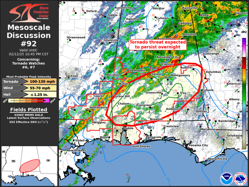
   Mesoscale Discussion 0092
   NWS Storm Prediction Center Norman OK
   0910 PM CST Wed Feb 12 2025

   Areas affected...southern AL

   Concerning...Tornado Watch 6...7...

   Valid 130310Z - 130445Z

   The severe weather threat for Tornado Watch 6, 7 continues.

   SUMMARY...Tornado and isolated damaging wind potential will persist
   into the overnight across parts of southern Alabama. A strong
   tornado remains possible, mainly through late evening.

   DISCUSSION...After a couple potentially strong tornadoes earlier
   this evening, a relative lull in convective intensity has been
   recently observed. With a lack of mid-level height falls across the
   warm-moist sector, in conjunction with a filling surface cyclone
   tonight, overall severe potential may have peaked. Still, strong
   low-level shear (0-1 km SRH around 350 m2/s2 per MOB VWP data) and
   upper 60s to low 70s surface dew points in much of the warm-moist
   sector, will remain favorable for a strong tornado with any
   sustained supercells along the slow-moving warm front. While the
   western portion of the front has been modified by prior convective
   outflow, the eastern portion of this boundary arced through
   Montgomery to Barbour County, AL (the MGM ASOS measured a 9 F
   temperature rise in 10 minutes during passage). It should continue
   advancing north in/towards the I-85 corridor, increasing tornado
   potential into this region later tonight.

   ..Grams.. 02/13/2025

   ...Please see www.spc.noaa.gov for graphic product...

   ATTN...WFO...TAE...BMX...MOB...

   LAT...LON   31568854 32078808 32428727 32728639 32808577 32788534
               32678510 32268512 31898526 31328596 30988684 30838768
               30858830 31168865 31568854
|


 @NWSSPC