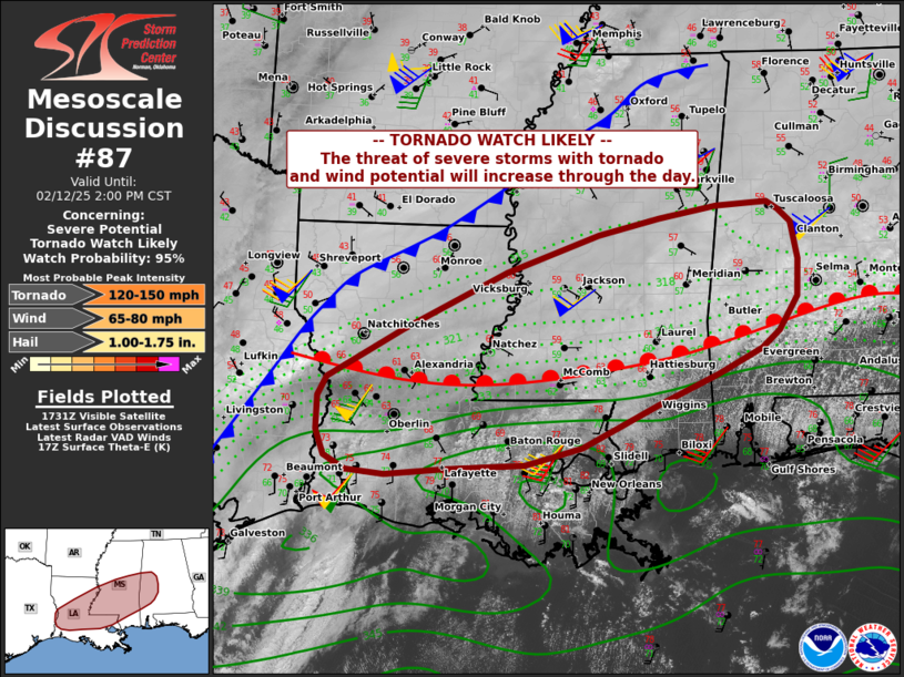
   Mesoscale Discussion 0087
   NWS Storm Prediction Center Norman OK
   1136 AM CST Wed Feb 12 2025

   Areas affected...central Louisiana across central and southern
   Mississippi and into west-central Alabama

   Concerning...Severe potential...Tornado Watch likely

   Valid 121736Z - 122000Z

   Probability of Watch Issuance...95 percent

   SUMMARY...Storms will increase along the cold front near the Sabine
   River, and near the warm front across Mississippi into Alabama.
   Scattered supercells are forecast, with several tornadoes possible
   later today.

   DISCUSSION...Surface analysis shows a low near the Sabine River with
   a cold front extending from southeast TX across northern LA/MS. A
   warm front currently stretches from the surface low eastward across
   southern MS, AL, and GA.

   The early day precipitation shield within the warm advection regime
   continues to lift north, while boundary-layer mixing and pockets of
   heating develop south of the warm front. Persistent southwest flow
   with over 40 kt at 850 mb will result in rapid air mass recovery
   over parts of central/northeast LA into central MS, and a portion of
   south-central/southwest AL.

   Initially, storms are expected to develop near or just ahead of the
   cold front as it moves out of TX and into western LA today. This air
   mass will continue to destabilize, with strong deep-layer shear and
   sufficient low-level SRH supporting a wind, tornado, and isolated
   hail threat.

   Later this afternoon and more aligned with the diurnal cycle,
   multiple supercells are expected to develop in the vicinity of the
   northward-advancing warm front from central/southern MS into western
   AL. Effective SRH to around 300 m2/s2 through 00Z along with a deep
   moistening boundary layer along with increasing large-scale ascent
   ahead of the cold front a suggest a strong tornado or two may occur.
   Current visible satellite and radar already show deepening
   convection over southeast LA, and this regime may be the beginnings
   of the supercell risk as it develops northeastward today.

   ..Jewell/Guyer.. 02/12/2025

   ...Please see www.spc.noaa.gov for graphic product...

   ATTN...WFO...BMX...MOB...JAN...LIX...LCH...SHV...

   LAT...LON   32898993 33098910 33238832 33278764 33188749 33028732
               32608723 32178724 31778749 31578773 31288833 30948914
               30449015 30259092 30209196 30139278 30189331 30349359
               30639371 31019370 31249358 31809257 32479116 32898993
|


 @NWSSPC