|
| Mesoscale Discussion 86 |
|
< Previous MD Next MD >
|
|
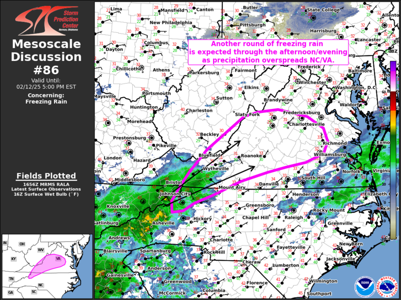
   Mesoscale Discussion 0086
   NWS Storm Prediction Center Norman OK
   1058 AM CST Wed Feb 12 2025

   Areas affected...Far northwest North Carolina into western and
   central Virginia

   Concerning...Freezing rain

   Valid 121658Z - 122200Z

   SUMMARY...Another round of freezing rain is expected through the
   late afternoon and evening hours in the lee of the Blue Ridge
   Mountains as precipitation advances northeastward.

   DISCUSSION...Regional radar mosaics show a swath of stratiform
   precipitation associated with a broad mid-level warm frontal zone
   spreading northeastward from northern MS/AL and TN into the western
   Carolinas. Downstream from the precipitation swath, surface
   temperatures in the lee of the Blue Ridge Mountains from far
   northwest NC into western and central VA remain below freezing. 12
   UTC soundings from GSO and RNK sampled a 4-7 C warm nose at about
   850 mb that will remain in place through the remainder of the day
   (if not strengthen) as warm advection increases ahead of an
   approaching upper disturbance. A combination of very limited daytime
   heating, continued cold air damming along the terrain, and minimal
   surface heat flux (due to recent ice accumulations of 0.25 to 0.5
   inch) will maintain a pocket of sub-freezing surface temperatures
   and support freezing rain as the primary precipitation type.

   The next round of freezing rain will likely begin as the upstream
   precipitation swath spreads northeast through the afternoon hours.
   Recent high-res solutions, which have captured overall precipitation
   trends well, suggest an onset time of around 18 UTC for far
   northwest NC and far southwest VA, and a later onset time of around
   20 UTC for western/central VA. Persistent warm advection  ahead of a
   deepening low to the west will support the potential for multiple
   rounds of freezing rain through late afternoon and into the evening
   hours with freezing rain rates generally between 0.03 to 0.06
   inches/hour (though locally higher rates appear possible).

   ..Moore.. 02/12/2025

   ...Please see www.spc.noaa.gov for graphic product...

   ATTN...WFO...AKQ...LWX...RNK...RLX...GSP...MRX...

   LAT...LON   36947909 36727990 36428065 36198128 36008162 35958194
               36228196 36598173 36928147 37488094 38307981 38407939
               38467876 38287787 37997739 37677727 37387739 37177793
               37077854 36947909
|
|
Top/All Mesoscale Discussions/Forecast Products/Home
|
|


 @NWSSPC