|
| Mesoscale Discussion 85 |
|
< Previous MD Next MD >
|
|
Mesoscale Discussion 0085
NWS Storm Prediction Center Norman OK
0616 AM CST Wed Feb 12 2025
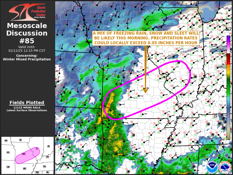
Areas affected...Southern and Central Missouri...South-central
Illinois
Concerning...Winter mixed precipitation
Valid 121216Z - 121815Z
SUMMARY...A mix of freezing rain, sleet and snow will be likely this
morning across parts of southwest Missouri east-northeastward into
south-central Illinois. Precipitation rates could exceed 0.05 inches
per hour.
DISCUSSION...A mid-level trough is currently analyzed across the
southern Rockies. Ahead of the trough, an area of precipitation is
ongoing within a zone of increasing large-scale ascent from the
eastern portions of the southern Plains into the Ozarks. Surface
temperatures are in the lower 30s F across most of Southwest
Missouri extending northeastward to the vicinity of St Louis.
Several RAP forecast soundings within this corridor have a warm nose
in the mid-levels between 700 and 800 mb, with temperatures near 0
C. This warm layer will result in a mix of precipitation types.
Freezing rain, sleet and snow will be possible as this area of
precipitation spreads northeastward. Precipitation across
southeastern Missouri, where the warm nose is more pronounced, will
be mostly freezing rain, while further to the north across
north-central Missouri, snow is expected to predominant. Locally,
heavy snowfall rates will be possible with the more intense bands.
..Broyles/Mosier.. 02/12/2025
...Please see www.spc.noaa.gov for graphic product...
ATTN...WFO...PAH...ILX...LSX...LZK...SGF...TSA...
LAT...LON 37439445 37949410 38379308 39059130 39499012 39608925
39428885 39218868 38998854 38628858 38198887 37828955
37519019 37129131 36499328 36529407 37059451 37439445
|
|
Top/All Mesoscale Discussions/Forecast Products/Home
|
|


 @NWSSPC