|
| Mesoscale Discussion 84 |
|
< Previous MD Next MD >
|
|
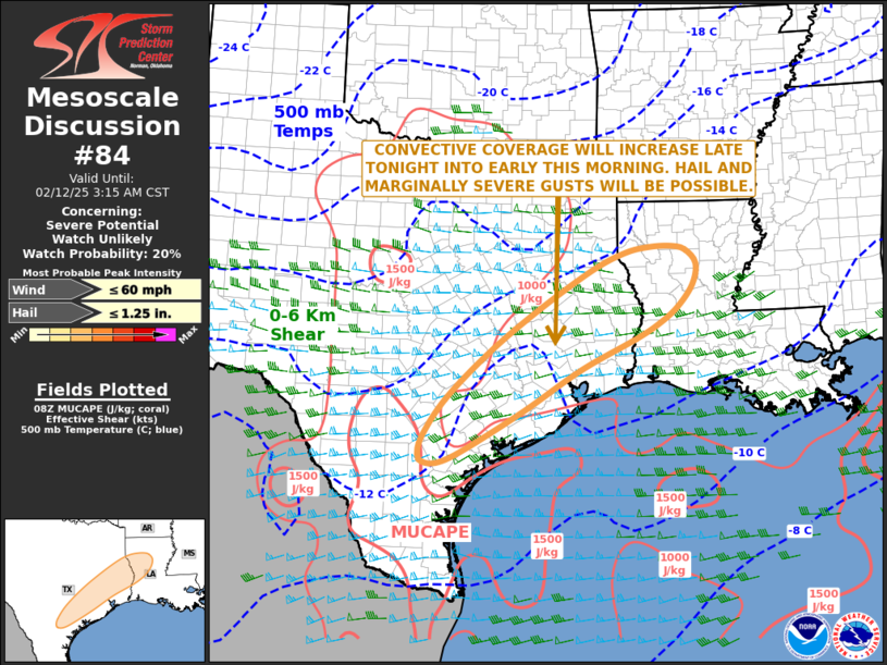
   Mesoscale Discussion 0084
   NWS Storm Prediction Center Norman OK
   0208 AM CST Wed Feb 12 2025

   Areas affected...Texas Coastal Plain...Western and Central Louisiana

   Concerning...Severe potential...Watch unlikely

   Valid 120808Z - 120915Z

   Probability of Watch Issuance...20 percent

   SUMMARY...A marginal severe threat, with strong wind gusts and hail,
   is expected to develop late tonight into early this morning across
   parts of the Texas Coastal Plain into parts of western and central
   Louisiana.

   DISCUSSION...A mid-level shortwave trough will approach the southern
   Plains late tonight. In response, moisture advection will continue
   across the Texas Coastal Plain. At the surface, a quasi-stationary
   front is analyzed from near Laredo northeastward to northwest of
   Victoria to near College Station. The stronger convection is located
   to the west of this boundary. The RAP has MUCAPE varying from around
   500 J/kg in southeast Texas to near 1500 J/kg in south Texas. As
   low-level moisture advection continues overnight, instability will
   gradually increase. Most RAP forecast soundings to the west of the
   front have a low-level temperature inversion, with effective shear
   above the inversion in the 50 to 60 knot range. This could support a
   marginal severe threat with the stronger elevated cores, with hail
   possible. As convective coverage increases, surface-based storms may
   develop near the front. The stronger cells could have marginally
   severe gusts, in addition to hail.

   ..Broyles/Mosier.. 02/12/2025

   ...Please see www.spc.noaa.gov for graphic product...

   ATTN...WFO...LCH...SHV...HGX...CRP...EWX...

   LAT...LON   29239601 28519726 28309777 28319806 28439815 28759808
               29459760 30319671 31089569 31789456 32109386 32199334
               32219289 32139262 31899240 31509247 31109280 30819317
               30539368 29989481 29239601
|
|
Top/All Mesoscale Discussions/Forecast Products/Home
|
|


 @NWSSPC