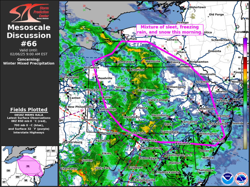
   Mesoscale Discussion 0066
   NWS Storm Prediction Center Norman OK
   0300 AM CST Thu Feb 06 2025

   Areas affected...much of Pennsylvania...northern Maryland...northern
   Delaware...western New Jersey...and southwestern New York.

   Concerning...Winter mixed precipitation

   Valid 060900Z - 061400Z

   SUMMARY...A mixture of sleet, freezing rain, and snow is expected
   this morning across portions of the central Appalachians into the
   Mid-Atlantic.

   DISCUSSION...A progressive shortwave trough and attendant mid-level
   jet streak are moving through the Ohio Valley this morning. Ahead of
   this trough, widespread stratiform rain, with some embedded
   convection, has developed within a region of dCVA and strong
   isentropic ascent. Expect this region of freezing rain, sleet, and
   snow to expand further this morning as ascent increases with an
   expanding/strengthening low-level jet. Temperatures remain in the
   mid to upper 20s across much of Pennsylvania and surrounding areas.
   These well-below freezing temperatures, combined with sustained 10
   mph winds, create an environment favorable for ice accretion this
   morning from Lake Erie to the Atlantic Ocean near New
   Jersey/Delaware. Temperatures are expected to warm above freezing
   across Delaware and New Jersey by daybreak as strengthening
   low-level southeasterly flow off the Gulf stream progresses inland.

   Isolated pockets of freezing rain, correlated with terrain, exist
   farther south across Virginia, but will eventually erode as warmer
   air advects into the region.

   ..Bentley.. 02/06/2025

   ...Please see www.spc.noaa.gov for graphic product...

   ATTN...WFO...PHI...BGM...BUF...CTP...LWX...PBZ...CLE...

   LAT...LON   42158037 42457948 42867907 42867784 42087593 41397507
               40447475 40147457 39567440 39257483 39407644 39417724
               39527801 39867893 40517967 42158037
|


 @NWSSPC