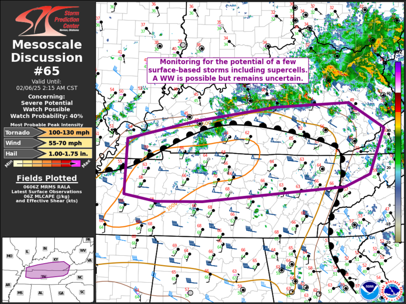
   Mesoscale Discussion 0065
   NWS Storm Prediction Center Norman OK
   1208 AM CST Thu Feb 06 2025

   Areas affected...portions of northern Tennessee and southern
   Kentucky

   Concerning...Severe potential...Watch possible

   Valid 060608Z - 060815Z

   Probability of Watch Issuance...40 percent

   SUMMARY...Ongoing weak destabilization within the warm air advection
   regime over the TN/KY border region could support surface-based
   storms and a risk for hail, damaging winds, or a tornado overnight.
   A WW is possible, but it remains unclear if one is needed.

   DISCUSSION...As of 0600 UTC, regional observations show weak, but
   likely surface-based, destabilization is ongoing over parts of the
   central MS River Valley and TN/KY border region. Large-scale ascent
   ahead of a low-amplitude shortwave trough over the Midwest is
   supporting persistent low-level warm air advection over much of the
   Mid south. Widespread predominately elevated convection, is ongoing
   north of the surface warm front over the OH Valley. While to the
   south, surface dewpoints in the middle to upper 60s F were advecting
   into western TN beneath fairly steep mid-level lapse rates around
   7-8 C/km. Sufficient to offset nocturnal stabilization, continued
   low-level theta-E advection is supporting weak to moderate MLCAPE of
   500-1000 J/kg.

   Surface-based storm development appears possible along and south of
   the frontal zone over north-central TN and far southern KY, and
   farther west along a cold front. Enlarged low-level hodographs,
   coupled with moderate to strong deep-layer shear, could foster a
   couple sustained surface-based supercells or short bowing segments
   capable of large hail, damaging winds and perhaps a tornado.

   Current observational trends and recent HRRR guidance show a gradual
   increase in convective coverage over the next few hours. It remains
   unclear how much of the convection will remain surface-based along
   and south of the front. However, with strong shear and sufficient
   moisture/buoyancy in place, the severe risk could warrant a WW and
   conditions will continue to be monitored.

   ..Lyons/Mosier.. 02/06/2025

   ...Please see www.spc.noaa.gov for graphic product...

   ATTN...WFO...MRX...JKL...LMK...OHX...PAH...MEG...

   LAT...LON   36898890 37278723 37558528 37628350 37108263 36218301
               35978361 35688706 35688817 35818894 36898890
|


 @NWSSPC