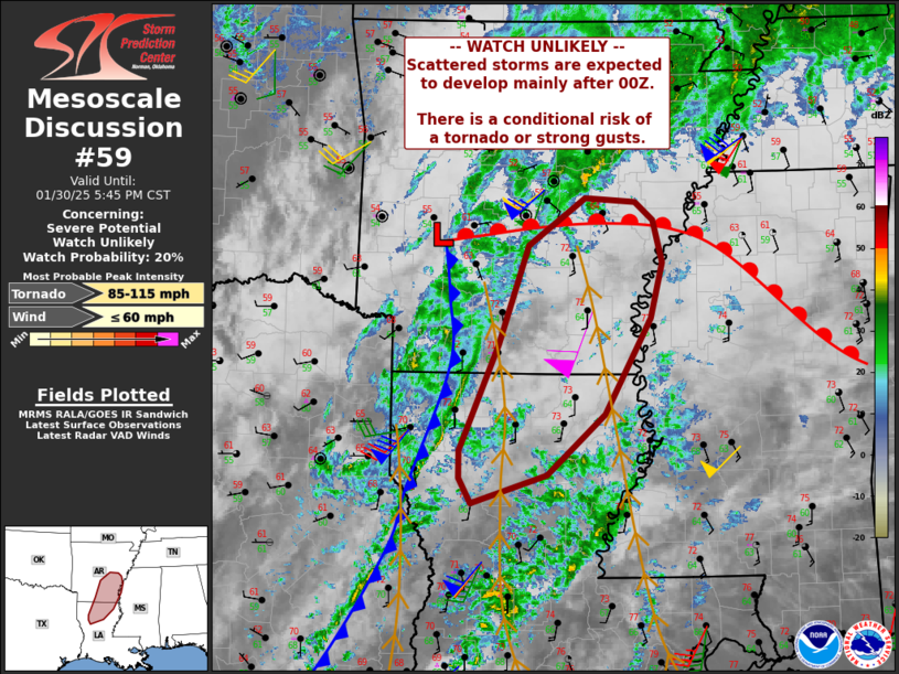
   Mesoscale Discussion 0059
   NWS Storm Prediction Center Norman OK
   0317 PM CST Thu Jan 30 2025

   Areas affected...parts of northern Louisiana and southern Arkansas

   Concerning...Severe potential...Watch unlikely

   Valid 302117Z - 302345Z

   Probability of Watch Issuance...20 percent

   SUMMARY...A gradual increase in thunderstorms is expected through
   this evening. Isolated severe storms capable of gusty winds or a
   brief tornado cannot be ruled out.

   DISCUSSION...A cold front continues to push across eastern TX, and
   now into southwest AR and northwest LA. Ahead of this front,
   persistent southerly winds have allowed for marginal destabilization
   via advection with MUCAPE over 500 J/kg as far north as southeast
   AR. Heating remains limited due to extensive pre-frontal clouds, and
   scattered showers over the warm sector.

   Although low to midlevel lapse rates are not particularly steep,
   lightning activity has increased over the last hour, suggesting the
   deepening moist boundary layer has breached the stable/capping
   layer. As such, increasing storm coverage is anticipated along and
   ahead of the cold front through this evening.

   Shear profiles favor supercells and tornado potential, with
   effective SRH now over 300 m2/s2, and, deep-layer shear vectors
   oriented with substantial component across the cold front. With
   time, a few of the storms could attain supercell characteristics,
   with a conditional risk of a brief tornado and/or damaging gusts.
   Trends will continue to be monitored over the next several hours.

   ..Jewell/Hart.. 01/30/2025

   ...Please see www.spc.noaa.gov for graphic product...

   ATTN...WFO...MEG...JAN...LZK...SHV...

   LAT...LON   34719118 34539097 34109085 33569100 32609153 32019221
               31729311 31979324 32259324 33309278 34289244 34759176
               34719118
|


 @NWSSPC