|
| Mesoscale Discussion 60 |
|
< Previous MD Next MD >
|
|
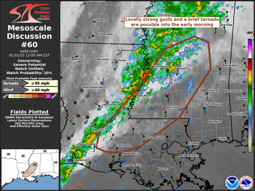
   Mesoscale Discussion 0060
   NWS Storm Prediction Center Norman OK
   1006 PM CST Thu Jan 30 2025

   Areas affected...central/southern portions of MS/LA

   Concerning...Severe potential...Watch unlikely

   Valid 310406Z - 310600Z

   Probability of Watch Issuance...20 percent

   SUMMARY...Locally strong gusts and a brief tornado should be the
   main threats into the early morning hours as broken thunderstorm
   clusters spread quickly east-northeast.

   DISCUSSION...The onset of mid-level height falls has aided in
   gradually deepening convection from southwest LA into southwest MS
   along a weak cold front. Despite strong low-level shear ahead of the
   front, instability remains quite limited with poor lapse rates
   evident in 00Z observed soundings. This is yielding meager buoyancy.
   Still, given the presence of pronounced mid/upper-level speed shear,
   in conjunction with the strengthening large-scale ascent, modestly
   organized clusters should rapidly spread east-northeast through
   about 08-09Z. Greater organizational structures may be subdued by
   orientation of the clusters paralleling the deep-layer shear vector.
   Locally strong gusts may occur, along with potential of a brief
   embedded tornado.

   ..Grams/Mosier.. 01/31/2025

   ...Please see www.spc.noaa.gov for graphic product...

   ATTN...WFO...JAN...LIX...LCH...

   LAT...LON   31849130 32889045 33218953 33058909 32328903 31029005
               30269123 30089182 30099232 30209261 30639252 31849130
|
|
Top/All Mesoscale Discussions/Forecast Products/Home
|
|


 @NWSSPC