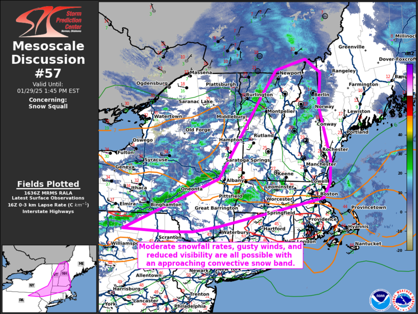
   Mesoscale Discussion 0057
   NWS Storm Prediction Center Norman OK
   1039 AM CST Wed Jan 29 2025

   Areas affected...portions of extreme northeast Pennsylvania...far
   eastern New York...Massachusetts...Vermont...New Hampshire

   Concerning...Snow Squall

   Valid 291639Z - 291845Z

   SUMMARY...Occasional snow-squall conditions are possible in stronger
   portions of a snow band over the next few hours. A rapid onset of
   moderate snow, gusty winds, and reduced visibility may all occur.

   DISCUSSION...A low-topped, progressive convective snow band has
   recently materialized, with a 10 F surface temperature drop,
   moderate snowfall rates, and half-mile visibility reductions noted
   on surface observations over the past couple of hours. This band is
   being driven by a progressive cold front and rapidly ejecting
   mid-level trough, which is also preceded by at least partially
   clearing skies. 16Z mesoanalysis shows up to 8 C/km low-level lapse
   rates downstream of the snow band, suggesting that snow squall
   potential may increase this afternoon in stronger convective cells.
   Bouts of at least moderate snowfall rates, as well as a 10 F
   temperature drop, 25+ kt gusts, and visibility reduced to a quarter
   mile, may occur with this band until it moves offshore.

   ..Squitieri.. 01/29/2025

   ...Please see www.spc.noaa.gov for graphic product...

   ATTN...WFO...GYX...BOX...BTV...ALY...BGM...

   LAT...LON   41657666 42767392 44517271 45077227 45297141 45007096
               44297103 43157069 42667073 42357092 42067231 41747391
               41617466 41617538 41657666
|


 @NWSSPC