|
| Mesoscale Discussion 56 |
|
< Previous MD Next MD >
|
|
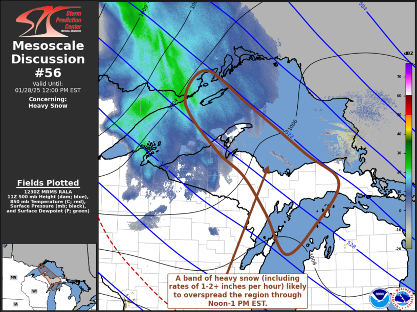
   Mesoscale Discussion 0056
   NWS Storm Prediction Center Norman OK
   0633 AM CST Tue Jan 28 2025

   Areas affected...the Upper Michigan vicinity

   Concerning...Heavy snow

   Valid 281233Z - 281700Z

   SUMMARY...A period of heavy snow, at rates on the order of 1-2+
   inches per hour, appears possible in a corridor overspreading the
   central Upper Peninsula of Michigan vicinity by midday.

   DISCUSSION...Downstream of a low-amplitude short wave perturbation,
   accompanying an intense (110+ kt at 500 mb) jet streak digging
   east-southeast of the Canadian Prairies, lower/mid-tropospheric warm
   advection is overspreading the Upper Midwest into Great Lakes
   region.  Associated forcing for ascent is becoming focused across
   the southwestern flank of an arctic air mass now entrenched across
   much of the Great Lakes region, particularly near a zone of strong
   lower/mid-tropospheric frontogenesis, which is forecast to shift
   from northwestern Ontario across the western Lake Superior and
   central Upper Peninsula of Michigan vicinity through 17-18z.

   Forecast soundings across this region indicate that the sub-freezing
   thermodynamic profiles are in the process of saturating, ahead of an
   ongoing band of moderate to heavy snow, which appears likely to be
   maintained through at least early afternoon.  Temperatures appear
   within a few degrees of -15C through an initially deep layer from
   lower-levels into the 700-600 mb layer, where conditions will be
   most conducive to large dendritic ice crystal growth.  Coinciding
   with maximizing lift associated with the frontogenetic forcing, it
   appears that this may support a 2-3 hour period of heavy snow rates
   on the order of 1-2 inches per hour.  Forecast soundings also
   indicate that a layer a steepening mid-level lapse rates may be
   accompanied by the development of weak CAPE and embedded convective
   development with heavier snow rates possible.

   ..Kerr.. 01/28/2025

   ...Please see www.spc.noaa.gov for graphic product...

   ATTN...WFO...APX...MQT...GRB...DLH...

   LAT...LON   48538911 47918791 46888619 46278519 45418590 44838674
               45668731 46428796 46938875 47878969 48538911
|
|
Top/All Mesoscale Discussions/Forecast Products/Home
|
|


 @NWSSPC