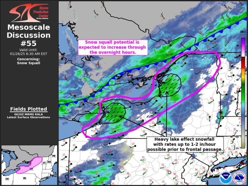
   Mesoscale Discussion 0055
   NWS Storm Prediction Center Norman OK
   1223 AM CST Tue Jan 28 2025

   Areas affected...North and western New York

   Concerning...Snow Squall

   Valid 280623Z - 281130Z

   SUMMARY...Brief, but intense, snow showers along a strong cold front
   will move into northern and western New York through the overnight
   hours. Ahead of the front, heavy snowfall rates up to 1-2
   inches/hour are possible along the northeastern shores of the Lower
   Great Lakes.

   DISCUSSION...A strong cold front, evident by a pronounced leading
   band of heavy snow showers, has been pushing southeast out of
   Ontario/Quebec over the past several hours. Higher reflectivity
   values (up to 30 dBz) and occasional lightning flashes have been
   noted along portions of the front, indicative of the deep convective
   nature of the snow bands. Wind gusts upwards of 20-25 mph have also
   been noted with the passage of the front across Ontario/Quebec, as
   well as occasional visibility reductions. Similar conditions are
   possible as the snow bands cross the Lower Great Lakes and move into
   northern and western NY. A combination of rapidly falling
   temperatures along/behind the front, bursts of heavy snow within the
   stronger bands, and winds gusting up to 25 mph will support snow
   squall conditions across northern/western NY, and possibly into
   central NY, over the next several hours.

   Prior to the passage of the front, southwesterly winds oriented
   along Lake Erie and Lake Ontario will continue to support moderate
   to heavy lake effect snow bands on the northeastern shores of both
   lakes. Recent surface observations have reported visibility
   reductions between 1/4 to 3/4 of a mile. Despite 20-30 mph winds,
   blowing snow model output suggests that these visibility reductions
   are attributable to moderate to heavy snowfall rates. Recent
   guidance supports this idea and hints that rates up to 1-2
   inches/hour are possible prior to the passage of the front.

   ..Moore.. 01/28/2025

   ...Please see www.spc.noaa.gov for graphic product...

   ATTN...WFO...BTV...ALY...BGM...BUF...CTP...CLE...

   LAT...LON   42287757 42067847 41987899 41977948 42047976 42197993
               42337993 42407972 42617936 42877914 43097911 43237913
               43387891 43517827 43417754 43457705 43567674 43827654
               44107653 44357633 44807553 45007507 45067476 45077399
               45067354 45037338 44897327 44657319 44427333 44217352
               43997380 43697430 42337741 42287757
|


 @NWSSPC